Suche Karten Messwerte Kataloge Über NUMIS Anbieter Datenquellen API
Hilfe Kontakt Inhalt Impressum Datenschutz Barrierefreiheit
NUMIS - Das niedersächsische Umweltportal NUMIS - Das niedersächsische Umweltportal
Suche
Karten
Messwerte
Kataloge
API
Alle Suchergebnisse
Geodatensatz

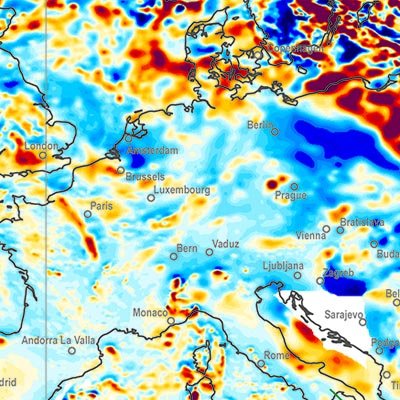
Earth Magnetic Anomaly Grid 1:35,000,000 (2 arc-minute resolution) (EMAG2)

Inhalt
  • Übersicht
  • Be­schrei­bung
    Aktualität des Datensatzes
  • Raumbezug
  • Verweise und Downloads
    Downloads Weitere Verweise
  • Nutzung
  • Kontakt
    Point of Contact
  • Fach­informationen
    Informationen zum Datensatz Zusatzinformationen Schlag­worte
  • Metadatensatz

Downloads (3)

EMAG2 (JPEG) EMAG2 im Format JPEG (Auflösung 150 dpi) [12.0 MB]
EMAG2 (PDF) EMAG2 im Format Adobe Acrobat Datei (geringe Auflösung) [2.0 MB]
Alle Links

Nutzungs­bedingun­gen

Allgemeine Geschäftsbedingungen, s. https://www.bgr.bund.de/agb - General Terms and Conditions, s. https://www.bgr.bund.de/agb_en

Point of Contact

Bundesanstalt für Geowissenschaften und Rohstoffe
Dr. Udo Barckhausen

Udo.Barckhausen@bgr.de

Vorschau

img

Be­schrei­bung

EMAG2

A global Earth Magnetic Anomaly Grid (EMAG2) was compiled from satellite, ship and airborne magnetic measurements. (Maus et al., 2009) Over the continents and the Arctic we made use of exisiting magnetic anomaly grids, whereas original ship and airborne trackline data were processed over the rest of the oceans, wherever available. CHAMP satellite magnetic measurements provided the magnetic field at wavelengths above 330 km. The EMAG2 grid is available at http://geomag.org and http://ngdc.noaa.gov. Directional gridding Due to the sparsity of magnetic field measurements in the southern oceans, it is necessary to interpolate the magnetic field between tracklines. Our interpolation algorithm takes the direction of the magnetic lineations into account. Tje lineations are parallel to the isochrons, which are perpendicular to the gradient of the age of teh oceanic crust. We use the age grid of Müller et al. (2008). The magnetic field ad a given grid point is computet by Least Squares Collocation from the surrounding measurements. If the point is on land, we use an isotropic correlation function with Rc = 14 km correlation length. Over the oceans we use Rc = 56 km parallel to the isochrons and Rc = 14 km in the spreading direction. Measurements seperated from the grid point by an age discontinuity or a topographic feature are excluded from the collation. A global Earth Magnetic Anomaly Grid (EMAG2) was compiled from satellite, ship and airborne magnetic measurements. (Maus et al., 2009) Over the continents and the Arctic we made use of exisiting magnetic anomaly grids, whereas original ship and airborne trackline data were processed over the rest of the oceans, wherever available. CHAMP satellite magnetic measurements provided the magnetic field at wavelengths above 330 km. The EMAG2 grid is available at http://geomag.org and http://ngdc.noaa.gov. Directional gridding Due to the sparsity of magnetic field measurements in the southern oceans, it is necessary to interpolate the magnetic field between tracklines. Our interpolation algorithm takes the direction of the magnetic lineations into account. Tje lineations are parallel to the isochrons, which are perpendicular to the gradient of the age of teh oceanic crust. We use the age grid of Müller et al. (2008). The magnetic field ad a given grid point is computet by Least Squares Collocation from the surrounding measurements. If the point is on land, we use an isotropic correlation function with Rc = 14 km correlation length. Over the oceans we use Rc = 56 km parallel to the isochrons and Rc = 14 km in the spreading direction. Measurements seperated from the grid point by an age discontinuity or a topographic feature are excluded from the collation.

Aktualität des Datensatzes

Publication

10.11.2010

Status

completed

Raumbezug

Lage der Geodaten (in WGS84)
SW Länge/Breite NO Länge/Breite
-180.0°/-90.0° 180.0°/90.0°
Koordinaten­system
EPSG:4326

Verweise und Downloads

Downloads (3)

EMAG2 (JPEG) EMAG2 im Format JPEG (Auflösung 150 dpi) [12.0 MB]
EMAG2 (PDF) EMAG2 im Format Adobe Acrobat Datei (geringe Auflösung) [2.0 MB]
EMAG2 (TIFF) EMAG2 im Format TIFF (Auflösung 300 dpi) [68.0 MB]

Weitere Verweise (2)

EMAG2 (gedruckt) Information EMAG2 im Format gedruckt, gefalzt
http://geomag.org/models/emag2.html Information EMAG2-Projekt im Internet - EMAG2-Project-Website

Nutzung

Nutzungs­bedingun­gen

Allgemeine Geschäftsbedingungen, s. https://www.bgr.bund.de/agb - General Terms and Conditions, s. https://www.bgr.bund.de/agb_en

Preis der gedruckten Karte: 13,83 EUR (zzgl. 7% MWSt. und Versandkosten) Weitere Informationen zur Bestellung beim Internationalen Landkartenhaus siehe https://www.bgr.bund.de/produktcenter-bestellhinweis-ILH

Zugriffs­beschränkun­gen

no limitations to public access

Kontakt

Point of Contact

Bundesanstalt für Geowissenschaften und Rohstoffe
Dr. Udo Barckhausen

Stilleweg 2
30655 Hannover
DE

Udo.Barckhausen@bgr.de

Fach­informationen

Informationen zum Datensatz

Identifikator

B3CCFEA1-9E87-4593-B4AB-6D441AA752C1

Digitale Repräsentation

Grid

Erstellungs­maß­stab
Maßstab 1:x

35000000

Fachliche Grundlage

Daten: NOAA, Boulder, CO, USA. Referenz: Maus, S., U. Barckhausen, et al. (2009), EMAG2: A 2-arc min resolution Earth Magnetic Anomaly Grid compiled from satellite, airborne, and ... , Geochem. Geophys. Geosyst., 10, doi: 10.1029/2009GC002471 - Data: NOAA, Boulder, CO, USA. Reference: Maus, S., U. Barckhausen, et al. (2009), EMAG2: A 2-arc min resolution Earth Magnetic Anomaly Grid compiled from satellite, airborne, and ... , Geochem. Geophys. Geosyst., 10, doi: 10.1029/2009GC002471

Zusatzinformationen

Sprache des Daten­satzes

Englisch

Datenformat
Name Version Kompressionstechnik Spezifi­kation
PDF n/a
JPEG n/a
TIFF n/a
gedruckt n/a

Schlag­worte

INSPIRE-Themen Geology
GEMET-Concepts geophysics Geophysik
ISO-Themen­kategorien Geoscientific Information
Suchbegriffe Earth magnetic field Erdmagnetfeld Weltkarte Weltweit world map

Informationen zum Metadatensatz

Objekt-ID

CF387546-B217-43D3-8781-8BEF8250253B

Aktualität der Metadaten

12.02.2025

Sprache Metadatensatz

Englisch

Datensatz / Datenserie  

Dataset

XML Dar­stellung
Metadaten als XML herunter­laden
Point of Contact (Metadatum)
geodatenmanagement@bgr.de
Metadatenquelle
GeoDaK (Datenkatalog der Bundesanstalt für Geowissenschaften und Rohstoffe)
ni_bubgr
TEST

NUMIS - Das niedersächsische Umweltportal
Niedersächsisches Ministerium für Umwelt,
Energie und Klimaschutz
Hilfe Kontakt Inhalt Impressum Datenschutz Barrierefreiheit
Nach oben

Hilfe

NUMIS NUMIS
UVP UVP