Suche Karten Messwerte Kataloge Über NUMIS Anbieter Datenquellen API
Hilfe Kontakt Inhalt Impressum Datenschutz Barrierefreiheit
NUMIS - Das niedersächsische Umweltportal NUMIS - Das niedersächsische Umweltportal
Suche
Karten
Messwerte
Kataloge
API
Alle Suchergebnisse
Geodatendienst
INSPIRE
Open Data

INSPIRE: Information system salt structures: planning basis, selection criteria and estimation of the potential for the construction of salt caverns for the storage of renewable energies (hydrogen and compressed air) (InSpEE) (WMS)

Inhalt
  • Übersicht
  • Be­schrei­bung
    Aktualität des Datensatzes
  • Raumbezug
  • Verweise und Downloads
    URL des Zugangs Querverweise Weitere Verweise
  • Nutzung
  • Kontakt
    Point of Contact Custodian
  • Fach­informationen
    Informationen zum Datensatz Zusatzinformationen Schlag­worte
  • Metadatensatz

URL des Zugangs (1)

https://services.bgr.de/wms/inspire_ge/inspee/?REQUEST=GetCapabilities&SERVICE=WMS

Querverweise (1)

INSPIRE: Information system salt structures: planning basis, selection criteria and estimation of the potential for the construction of salt caverns for the storage of renewable energies (hydrogen and compressed air) (InSpEE)
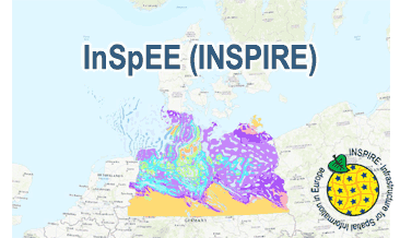
InSpEE (INSPIRE) provides information about the areal distribution of salt structures (salt domes and salt pillows) in Northern Germany. Contours of the salt structures can be displayed at horizontal cross-sections at four different depths up to a maximum depth of 2000 m below NN. The geodata have resulted from a BMWi-funded research project “InSpEE” running from the year 2012 to 2015. The acronym stands for "Information system salt structures: planning basis, selection criteria and estimation of the potential for the construction of salt caverns for the storage of renewable energies (hydrogen and compressed air)”. Additionally four horizontal cross-section maps display the stratigraphical situation at a given depth. In concurrence of maps at different depths areal bedding conditions can be determined, e.g. to generally assess and interpret the spread of different stratigraphic units. Clearly visible are extent and shape of the salt structures within their regional context at the different depths, with extent and boundary of the salt structures having been the main focus of the project. Four horizontal cross-section maps covering the whole onshore area of Northern Germany have been developed at a scale of 1:500.000. The maps cover the depths of -500, -1000, -1500, -2000 m below NN. The four depths are based on typical depth requirements of existing salt caverns in Northern Germany, mainly related to hydrocarbon storage. The shapes of the structures show rudimentary information of their geometry and their change with depths. In addition they form the starting point for rock mechanical calculations necessary for the planning and construction of salt caverns for storage as well as for assessing storage potentials. The maps can be used as a pre-selection tool for subsurface uses. It can also be used to assess coverage and extension of salt structures. Offshore areas were not treated within the project. All horizontal cross-section maps were adjusted with the respective state geological survey organisations. According to the Data Specification on Geology (D2.8.II.4_v3.0) the content of InSpEE (INSPIRE) is stored in 15 INSPIRE-compliant GML files: InSpEE_GeologicUnit_Salt_structure_types.gml contains the salt structure types (salt domes and salt pillows), InSpEE_GeologicUnit_Salt_pillow_remnants.gml comprises the salt pillow remnants, InSpEE_GeologicUnit_Structure_building_salinar.gml represents the structural salinar(s), the four files InSpEE_Structural_outlines_500.gml, InSpEE_Structural_outlines_1000.gml, InSpEE_Structural_outlines_1500.gml and InSpEE_Structural_outlines_2000.gml represent the structural outlines in the corresponding horizontal cross-sections, the four files InSpEE_GeologicUnit_Cross_Section_500, InSpEE_GeologicUnit_Cross_Section_1000, InSpEE_GeologicUnit_Cross_Section_1500 and InSpEE_GeologicUnit_Cross_Section_2000 display the stratigraphical situation in the corresponding horizontal cross-sections and the four files InSpEE_GeologicStructure_500.gml, InSpEE_GeologicStructure_1000.gml, InSpEE_GeologicStructure_1500.gml and InSpEE_GeologicStructure_2000.gml comprise the relevant fault traces in the corresponding horizontal cross-sections. The GML files together with a Readme.txt file are provided in ZIP format (InSpEE-INSPIRE.zip). The Readme.text file (German/English) contains detailed information on the GML files content. Data transformation was proceeded by using the INSPIRE Solution Pack for FME according to the INSPIRE requirements.

Nutzungs­bedingun­gen

Terms of Use: General terms and conditions, see https://www.bgr.bund.de/AGB_en. For further use provided information has to be cited as follows: InSpEE, (c) BGR Hannover, 2020

Point of Contact

Bundesanstalt für Geowissenschaften und Rohstoffe (BGR)

GeolUntergrund-Berlin@BGR.de

Vorschau

img

Kartenansicht öffnen

Be­schrei­bung

InSpEE (WMS) (INSPIRE)

The WMS InSpEE (INSPIRE) provides information about the areal distribution of salt structures (salt domes and salt pillows) in Northern Germany. Contours of the salt structures can be displayed at horizontal cross-sections at four different depths up to a maximum depth of 2000 m below NN. The geodata have resulted from a BMWi-funded research project “InSpEE” running from the year 2012 to 2015. The acronym stands for "Information system salt structures: planning basis, selection criteria and estimation of the potential for the construction of salt caverns for the storage of renewable energies (hydrogen and compressed air)”. Taking into account the fact that this work was undertaken at a scale for providing an overview and not for investigation of single structures, the scale of display is limited to a minimum of 1:300.000. Additionally four horizontal cross-section maps display the stratigraphical situation at a given depth. In concurrence of maps at different depths areal bedding conditions can be determined, e.g. to generally assess and interpret the spread of different stratigraphic units. Clearly visible are extent and shape of the salt structures within their regional context at the different depths, with extent and boundary of the salt structures having been the main focus of the project. Four horizontal cross-section maps covering the whole onshore area of Northern Germany have been developed at a scale of 1:500.000. The maps cover the depths of -500, -1000, -1500, -2000 m below NN. The four depths are based on typical depth requirements of existing salt caverns in Northern Germany, mainly related to hydrocarbon storage. The shapes of the structures show rudimentary information of their geometry and their change with depths. In addition they form the starting point for rock mechanical calculations necessary for the planning and construction of salt caverns for storage as well as for assessing storage potentials. The maps can be used as a pre-selection tool for subsurface uses. It can also be used to assess coverage and extension of salt structures. Offshore areas were not treated within the project. All horizontal cross-section maps were adjusted with the respective state geological survey organisations. According to the Data Specification on Geology (D2.8.II.4_v3.0) the WMS InSpEE (INSPIRE) provides INSPIRE-compliant data. The WMS InSpEE (INSPIRE) contains two group layers: The first group layer “INSPIRE: Salt structures in Northern Germany“ comprises the layers GE.Geologic.Unit.Salt structure types, GE.GeologicUnit.Salt pillow remnants, GE.GeologicUnit.Structure-building salinar and GE.GeologicUnit.Structural outlines. The layer GE.GeologicUnit.Structural outlines contains according to the four depths four sublayers, e.g. GE.GeologiUnit.Structural outlines 500 m below NN. The second group layer „INSPIRE: Horizontal cross-section maps of Northern Germany“ comprises according to the four depths four layers, e.g. Horizontal cross-section map – 500 m below NN. This layer, in turns, contains two sublayers: GE.GeologicFault.Relevant fault traces and GE.GeologicUnit.Stratigraphic Units. Via the getFeatureInfo request the user obtains additional information on the different geometries. In case of the GE.Geologic.Unit.Salt structure types the user gets access to a data sheet with additional information and further reading in German for the respective salt structure via the getFeatureInfo request. Der WMS InSpEE (INSPIRE) liefert Informationen zur räumlichen Verteilung von Salzstrukturen (Salzstöcke und Salzkissen) in Norddeutschland. Salzstrukturumrisse werden in vier Tiefenschnitten bis zu einer maximalen Tiefe von 2000 m u. NN angezeigt. Die Geodaten stammen aus dem BMWi-geförderten Forschungsprojekt „InSpEE“(Laufzeit 2012-2015). Das Akronym steht für „Informationssystem Salzstrukturen: Planungsgrundlagen, Auswahlkriterien und Potenzialabschätzung für die Errichtung von Salzkavernen zur Speicherung von Erneuerbaren Energien (Wasserstoff und Druckluft)". Der Darstellungsmaßstab hat eine untere Grenze von 1:300.000, da der Bearbeitungsmaßstab des Systems nicht für Einzelstrukturuntersuchungen geeignet ist. Zusätzlich bilden vier Niveauschnittkarten die stratigraphischen Verhältnisse in einer einheitlichen Tiefe ab. Im Zusammenwirken mehrerer Karten unterschiedlicher Tiefe lassen sich Lagerungsverhältnisse im Raum erfassen. So lässt sich die Ausdehnung verschiedener stratigrafischer Einheiten übersichtsmäßig abschätzen und interpretieren. Man erkennt die Ausdehnung und Form von Salinarstrukturen in verschiedenen Teufen, sowie deren Einordnung im regionalen Kontext. Der Schwerpunkt lag dabei auf der Abgrenzung der Salzstrukturen in den entsprechenden Tiefen. Für das Projekt InSpEE wurden flächendeckend für den Festlandsbereich Norddeutschlands Niveauschnittkarten in vier verschiedenen Tiefenniveaus von -500, -1000, -1500, -2000 m unter NN, im Maßstab 1:500.000 erarbeitet. Die gewählten Tiefenniveaus basieren auf der gängigen Tiefenlage bestehender Kavernen in Norddeutschland, die im Wesentlichen zur Speicherung von Kohlenwasserstoffen dienen. Die in den Karten enthaltenen Strukturumrisse zeigen im Ansatz Informationen zur Geometrie der entsprechenden Struktur und deren Veränderung mit zunehmender Tiefe und zum anderen bilden sie den Ausgangspunkt für die im Kavernenbau notwendigen gebirgsmechanischen Berechnungen und Potenzialabschätzungen. Die Karten können zur Vorauswahl von Regionen für verschiedene Untergrundnutzungen ebenso genutzt werden, wie zur Abschätzung der Überdeckung und Ausdehnung von Salzstrukturen. Offshorebereiche wurden bei der Bearbeitung nicht berücksichtigt. Alle Niveauschnittkarten wurden mit den jeweils zuständigen Staatlichen Geologischen Diensten (SGD) der Bundesländer abgestimmt. Entsprechend der Datenspezifikation Geology (D2.8.II.4_v3.0) liegen die WMS InSpEE (INSPIRE)-Inhalte INSPIRE-konform vor. Der WMS InSpEE (INSPIRE) enthält zwei Gruppenlayer: Der erste Gruppenlayer „INSPIRE: Salt structures in Northern Germany“ beinhaltet die Layer GE.Geologic.Unit.Salt structure types (Salzstrukturtypen), GE.GeologicUnit.Salt pillow remnants (Kissenfüße), GE.GeologicUnit.Structure-building salinar (Strukturaufbauendes Salinar) und GE.GeologicUnit.Structural outlines (Strukturumrisse). Der Layer GE.GeologicUnit.Structural outlines umfasst entsprechend der vier Tiefenniveaus vier Sublayer, z.B. GE.GeologiUnit.Structural outlines 500 m below NN. Der zweite Gruppenlayer „INSPIRE: Horizontal cross-section maps of Northern Germany“ beinhaltet entsprechend der vier Tiefenniveaus vier Layer, z.B. Horizontal cross-section map – 500 m below NN. Dieser Layer wiederum umfasst die zwei Sublayer GE.GeologicFault.Relevant fault traces (Relevante Störungsspuren) und GE.GeologicUnit.Stratigraphic Units (Stratigraphische Einheiten). Mit Hilfe der getFeatureInfo-Anfrage erhält der User weitere Informationen zu den einzelnen Geometrien. Im Falle von GE.Geologic.Unit.Salt structure types erhält der User über die getFeatureInfo-Anfrage Zugang zu einem Datenblatt mit zusätzlichen Informationen und weiterführender Literatur in deutscher Sprache zu der jeweiligen Salzstruktur.

Aktualität des Datensatzes

Publication

21.02.2020

Status

completed

Raumbezug

Lage der Geodaten (in WGS84)
SW Länge/Breite NO Länge/Breite
4.041°/51.318° 15.345°/55.735°
Koordinaten­system
EPSG:25832

Verweise und Downloads

URL des Zugangs (1)

https://services.bgr.de/wms/inspire_ge/inspee/?REQUEST=GetCapabilities&SERVICE=WMS

Querverweise (1)

Geodatensatz
INSPIRE: Information system salt structures: planning basis, selection criteria and estimation of the potential for the construction of salt caverns for the storage of renewable energies (hydrogen and compressed air) (InSpEE)
img
InSpEE (INSPIRE) provides information about the areal distribution of salt structures (salt domes and salt pillows) in Northern Germany. Contours of the salt structures can be displayed at horizontal cross-sections at four different depths up to a maximum depth of 2000 m below NN. The geodata have resulted from a BMWi-funded research project “InSpEE” running from the year 2012 to 2015. The acronym stands for "Information system salt structures: planning basis, selection criteria and estimation of the potential for the construction of salt caverns for the storage of renewable energies (hydrogen and compressed air)”. Additionally four horizontal cross-section maps display the stratigraphical situation at a given depth. In concurrence of maps at different depths areal bedding conditions can be determined, e.g. to generally assess and interpret the spread of different stratigraphic units. Clearly visible are extent and shape of the salt structures within their regional context at the different depths, with extent and boundary of the salt structures having been the main focus of the project. Four horizontal cross-section maps covering the whole onshore area of Northern Germany have been developed at a scale of 1:500.000. The maps cover the depths of -500, -1000, -1500, -2000 m below NN. The four depths are based on typical depth requirements of existing salt caverns in Northern Germany, mainly related to hydrocarbon storage. The shapes of the structures show rudimentary information of their geometry and their change with depths. In addition they form the starting point for rock mechanical calculations necessary for the planning and construction of salt caverns for storage as well as for assessing storage potentials. The maps can be used as a pre-selection tool for subsurface uses. It can also be used to assess coverage and extension of salt structures. Offshore areas were not treated within the project. All horizontal cross-section maps were adjusted with the respective state geological survey organisations. According to the Data Specification on Geology (D2.8.II.4_v3.0) the content of InSpEE (INSPIRE) is stored in 15 INSPIRE-compliant GML files: InSpEE_GeologicUnit_Salt_structure_types.gml contains the salt structure types (salt domes and salt pillows), InSpEE_GeologicUnit_Salt_pillow_remnants.gml comprises the salt pillow remnants, InSpEE_GeologicUnit_Structure_building_salinar.gml represents the structural salinar(s), the four files InSpEE_Structural_outlines_500.gml, InSpEE_Structural_outlines_1000.gml, InSpEE_Structural_outlines_1500.gml and InSpEE_Structural_outlines_2000.gml represent the structural outlines in the corresponding horizontal cross-sections, the four files InSpEE_GeologicUnit_Cross_Section_500, InSpEE_GeologicUnit_Cross_Section_1000, InSpEE_GeologicUnit_Cross_Section_1500 and InSpEE_GeologicUnit_Cross_Section_2000 display the stratigraphical situation in the corresponding horizontal cross-sections and the four files InSpEE_GeologicStructure_500.gml, InSpEE_GeologicStructure_1000.gml, InSpEE_GeologicStructure_1500.gml and InSpEE_GeologicStructure_2000.gml comprise the relevant fault traces in the corresponding horizontal cross-sections. The GML files together with a Readme.txt file are provided in ZIP format (InSpEE-INSPIRE.zip). The Readme.text file (German/English) contains detailed information on the GML files content. Data transformation was proceeded by using the INSPIRE Solution Pack for FME according to the INSPIRE requirements.

Weitere Verweise (2)

https://services.bgr.de/inspire/inspee Information Karte im BGR-Geoviewer
https://services.bgr.de/wms/inspire_ge/inspee/?REQUEST=GetCapabilities&SERVICE=wms&VERSION=1.3.0

Nutzung

Nutzungs­bedingun­gen

Terms of Use: General terms and conditions, see https://www.bgr.bund.de/AGB_en. For further use provided information has to be cited as follows: InSpEE, (c) BGR Hannover, 2020

Dieser Datensatz kann gemäß der "Nutzungsbestimmungen für die Bereitstellung von Geodaten des Bundes" (https://sg.geodatenzentrum.de/web_public/gdz/lizenz/geonutzv.pdf) genutzt werden.

Zugriffs­beschränkun­gen

no limitations to public access

Kontakt

Point of Contact

Bundesanstalt für Geowissenschaften und Rohstoffe (BGR)

Stilleweg 2
30655 Hannover
DE

GeolUntergrund-Berlin@BGR.de
Custodian

Bundesanstalt für Geowissenschaften und Rohstoffe (BGR)

geodatenmanagement@bgr.de

Fach­informationen

Informationen zum Datensatz

Art des Dienstes

View Service

Version

OGC:WMS 1.3.0

Fachliche Grundlage

The WMS InSpEE (INSPIRE) is based on the InSpEE spatial datasets (Salt structures in Northern Germany and Horizontal cross-section maps of Northern Germany) transformed according to INSPIRE.

Operation
Name der Operation Beschreibung der Operation Aufruf der Operation
GetCapabilities

https://services.bgr.de/wms/inspire_ge/inspee/?

GetMap

https://services.bgr.de/wms/inspire_ge/inspee/?

Get­Ca­pa­bi­li­ties Do­ku­ment
Get­Ca­pa­bi­li­ties an­zei­gen
Kartenansicht öffnen

Zusatzinformationen

Kon­formi­tät
Spezifi­kation der Kon­formi­tät Spezifi­kations­datum Grad der Kon­formi­tät Geprüft mit
Technical Guidance for the implementation of INSPIRE View Services 04.04.2013 See the referenced specification
VERORDNUNG (EG) Nr. 976/2009 DER KOMMISSION vom 19. Oktober 2009 zur Durchführung der Richtlinie 2007/2/EG des Europäischen Parlaments und des Rates hinsichtlich der Netzdienste 20.10.2009 See the referenced specification
Datenformat
Name Version Kompressionstechnik Spezifi­kation
png n/a
jpeg n/a
gif n/a

Schlag­worte

INSPIRE-Themen Geology
INSPIRE - Räumlicher An­wen­dungs­bereich Regional
Suchbegriffe Diapir Energiespeicher Energiespeicherung Energieträger Erneuerbare Energiequelle infoMapAccessService inspireidentifiziert Jura Kavernen Keuper Norddeutschland Northern Germany opendata Perm Petrographie petrography Salinar Salzintrusion Salzkissen Salzstock Salzstruktur Stratigraphie stratigraphy tectonics Tektonik Zechstein

Informationen zum Metadatensatz

Objekt-ID

cfa46e59-bcb4-40b7-a1aa-f26a463c12e4

Aktualität der Metadaten

23.01.2024

Sprache Metadatensatz

Englisch

XML Dar­stellung
Metadaten als XML herunter­laden
Point of Contact (Metadatum)
geodatenmanagement@bgr.de
Metadatenquelle
GeoDaK (Datenkatalog der Bundesanstalt für Geowissenschaften und Rohstoffe)
ni_bubgr
TEST

NUMIS - Das niedersächsische Umweltportal
Niedersächsisches Ministerium für Umwelt,
Energie und Klimaschutz
Hilfe Kontakt Inhalt Impressum Datenschutz Barrierefreiheit
Nach oben

Hilfe

NUMIS NUMIS
UVP UVP