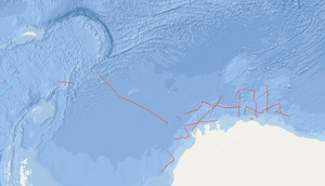
The preceding results of the Deep Sea Drilling Project/International Program of Ocean Drilling (DSDP/IPOD) have shown that inspection of borehole cores in the Southern Ocean and around Antarctica are necessary for reconstruction of the development of the Atlantic Ocean and for the understanding of the sedimentary deposition which is strongly affected by the palaeo-oceanographic processes. As the geological development of the Weddell Sea plays a key role for the reconstruction of the south-american and african part of the former supercontinent Gondwana, the Federal Institute for Geosciences and Natural Resources (BGR) has decided to conduct a synoptic geophysical survey in the eastern Weddell Sea and in front of the eastern Antarctic continental margin. This survey has been designed as a prearrangement for a larger "presite" program for preparation of future DSDP/IPOD sites. The main focus of the geophysical survey during the first leg of cruise BGR78 from 5th of January to 13th of February 1978 with M.S. EXPLORA has been put on the continental margin of the south-eastern Weddell Sea and eastern Antarctica between 20°E and 30°W and south of 67°S. Especially the lines BGR78-03 to BGR78-23 of seismic reflection measurements have been carried out in this region which were affected by heavy ice conditions at this time. Additionally, on 43 stations sonobuoy refraction measurements have been conducted. Die bisherigen Ergebnisse des Deep Sea Drilling Project/International Program of Ocean Drilling (DSDP/IPOD) haben gezeigt, dass für die Rekonstruktion der Entwicklung des Atlantiks und zum besseren Verständnis der die Sedimentationsvorgänge entscheidend prägenden Paläoozeanographie Bohraufschlüsse im Südatlantik und in der Umgebung der Antarktis notwendig sind. Da das Weddell-Meer speziell für die Rekonstruktion des südamerikanisch-afrikanischen Teils von Gondwana eine Schlüsselstellung hat, ist von der Bundesanstalt für Geowissenschaften und Rohstoffe (BGR) im Rahmen eines größeren, zur Vorbereitung von zukünftigen DSDP/IPOD-Bohrungen ausgelegten "Presite"-Programms auch eine geophysikalische Übersichtsvermessung im östlichen Weddell-Meer und im Bereich des ostantarktischen Kontinentrandes geplant worden. Schwerpunktsgebiet der geophysikalischen Messungen auf dem ersten Fahrtabschnitt der Fahrt BGR78 vom 5. Januar bis zum 13. Februar 1978 mit dem M.S. EXPLORA war der Kontinentrandbereich des südöstlichen Weddell-Meeres und der Ostantarktis zwischen 20° östlicher Länge und 30° westlicher Länge und südlich des 67. Breitengrades. In diesem durch schwierige Eisverhältnisse ausgezeichnetem Seegebiet sind die Profile BGR78-03 bis BGR78-23 geophysikalisch vermessen worden. Auf 24 Stationen sind zudem refraktionsseismische Messungen mit Sonobojen durchgeführt worden.
Raumbezug
Lage der Geodaten (in WGS84)
| SW Länge/Breite | NO Länge/Breite | |
|---|---|---|
| -37.99°/-74.188° | 18.82°/-60.004° |
| Koordinatensystem |
|---|
Verweise und Downloads
Weitere Verweise (23)
| Identifikator des übergeordneten Metadatensatzes |
06a73c56-06a2-40d8-b806-466222b0760d |
|---|
Nutzung
| Nutzungsbedingungen |
Allgemeine Geschäftsbedingungen, siehe http://www.bgr.bund.de/AGB - General terms and conditions, see http://www.bgr.bund.de/AGB_en. Die bereitgestellten Informationen sind bei Weiterverwendung wie folgt zu zitieren: Datenquelle: BGR78-1 1978, (c) BGR, Hannover, 2019 |
|---|
| Zugriffsbeschränkungen |
no limitations to public access |
|---|
Kontakt
Fachinformationen
Informationen zum Datensatz
| Identifikator |
77a3af74-68be-5e35-bf41-457d9336493a |
|---|
| Digitale Repräsentation |
Vector |
|---|
| Fachliche Grundlage |
During the period from 5th January 1978 to 13th February 1978 BGR acquired seismic lines in the Southern Ocean, in the Weddell Sea, in the Lazarev Sea and the Riiser-Larsen Sea along the eastern antarctic continental margin. The lines BGR78-04 and BGR78-17 consist of raw data. The lines BGR78-01, BGR78-02, BGR78-03, BGR78-05, BGR78-06, BGR78-07, BGR78-08, BGR78-09, BGR78-10, BGR78-11, BGR78-12, BGR78-13, BGR78-14, BGR78-16, BGR78-18, BGR78-19, BGR78-20, BGR78-20A, BGR78-21, BGR78-22, BGR78-22A and BGR78-23 are stacked data. |
|---|
Zusatzinformationen
| Sprache des Datensatzes |
Englisch |
|---|
Konformität
| Spezifikation der Konformität | Spezifikationsdatum | Grad der Konformität | Geprüft mit |
|---|---|---|---|
| VERORDNUNG (EG) Nr. 1089/2010 DER KOMMISSION vom 23. November 2010 zur Durchführung der Richtlinie 2007/2/EG des Europäischen Parlaments und des Rates hinsichtlich der Interoperabilität von Geodatensätzen und -diensten | 08.12.2010 | siehe dazu die angegebene Durchführungsbestimmung |
Datenformat
| Name | Version | Kompressionstechnik | Spezifikation |
|---|---|---|---|
| Shapefile | n/a |
Schlagworte
| INSPIRE-Themen | Geology |
| GEMET-Concepts | geophysics Geophysik raw material Rohstoff |
| ISO-Themenkategorien | Geoscientific Information |
| Suchbegriffe | Eastern Antarctic Continental Margin Geologie geology geophysics Geophysik Lasarew-See Lazarev Sea Marine geology Meeresgeologie Ostantarktischer Kontinentalrand |
Informationen zum Metadatensatz
| Objekt-ID |
1aba1a87-7d19-4ccd-8d20-577d1f71260c |
|---|
| Aktualität der Metadaten |
14.11.2023 |
|---|
| Sprache Metadatensatz |
Englisch |
|---|
| Datensatz / Datenserie |
Dataset |
|---|
| XML Darstellung |
|---|
| Point of Contact (Metadatum) |
|---|
| Metadatenquelle |
GeoDaK (Datenkatalog der Bundesanstalt für Geowissenschaften und Rohstoffe)
|
|---|---|
|
ni_bubgr
|


