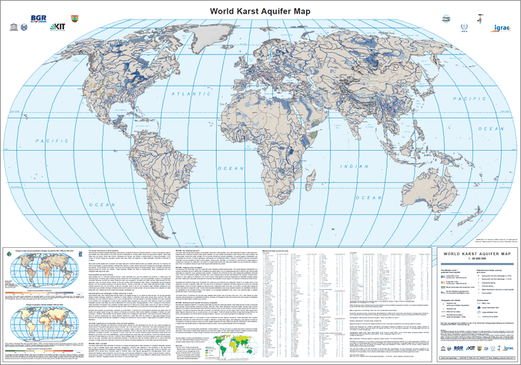
The World-wide Hydrogeological Mapping and Assessment Programme (WHYMAP) provides data and information about the earth´s major groundwater resources. The World Karst Aquifer Map (WOKAM) allows a more precise global quantification of karst systems. The map will help to increase awareness of karst groundwater resources in the context of global water issues and will serve as a basis for other karst-related research questions at global scales: for example those related to climate change, biodiversity, food production, geochemical cycles and urbanisation. Das World-wide Hydrogeological Mapping and Assessment Programme (WHYMAP) stellt Daten und Informationen über die weltweiten Grundwasservorkommen bereit. Die Weltkarte der Karstaquifere (WOKAM) ermöglicht eine präzisere globale Quantifizierung von Karst-Systemen. Sie wird dazu beitragen, das Bewusstsein für Karst-Grundwasserressourcen im Kontext globaler Wasserfragen zu stärken und wird als Grundlage für andere karstbezogene Forschungsfragen auf globaler Ebene dienen: zum Beispiel in Bezug auf Klimawandel, Biodiversität, Nahrungsmittelproduktion, geochemische Zyklen und Urbanisierung.
Raumbezug
Lage der Geodaten (in WGS84)
| SW Länge/Breite | NO Länge/Breite | |
|---|---|---|
| -180.0°/-90.0° | 180.0°/90.0° |
| Koordinatensystem |
|---|
Verweise und Downloads
Querverweise (1)
WMS
Geodatendienst
World Karst Aquifer Map (WHYMAP WOKAM) (WMS)
The World-wide Hydrogeological Mapping and Assessment Programme (WHYMAP) provides data and information about the earth´s major groundwater resources. The World Karst Aquifer Map (WOKAM) allows a more precise global quantification of karst systems. The map will help to increase awareness of karst groundwater resources in the context of global water issues and will serve as a basis for other karst-related research questions at global scales: for example those related to climate change, biodiversity, food production, geochemical cycles and urbanisation.
Kartenansicht öffnen
Weitere Verweise (1)
https://services.bgr.de/grundwasser/whymap_wokam
Information
Karte im BGR-Geoviewer
Nutzung
| Nutzungsbedingungen |
Allgemeine Geschäftsbedingungen, siehe https://www.bgr.bund.de/AGB - General terms and conditions, see https://www.bgr.bund.de/AGB_en. Die bereitgestellten Informationen sind bei Weiterverwendung wie folgt zu zitieren: Datenquelle: WHYMAP WOKAM, (C) BGR Berlin, IAH Reading, KIT Karlsruhe, UNESCO Paris 2017 |
|---|
| Zugriffsbeschränkungen |
no limitations to public access |
|---|
Kontakt
Fachinformationen
Informationen zum Datensatz
| Identifikator |
6e557f76-ac0a-404b-bad1-045b291d88cd |
|---|
| Digitale Repräsentation |
Vector |
|---|
Erstellungsmaßstab
| Maßstab 1:x |
25000000 |
|---|
| Fachliche Grundlage |
World-wide Hydrogeological Mapping and Assessment Programme (WHYMAP) |
|---|
Zusatzinformationen
| Sprache des Datensatzes |
Englisch |
|---|
Konformität
| Spezifikation der Konformität | Spezifikationsdatum | Grad der Konformität | Geprüft mit |
|---|---|---|---|
| VERORDNUNG (EG) Nr. 1089/2010 DER KOMMISSION vom 23. November 2010 zur Durchführung der Richtlinie 2007/2/EG des Europäischen Parlaments und des Rates hinsichtlich der Interoperabilität von Geodatensätzen und -diensten | 08.12.2010 | siehe dazu die angegebene Durchführungsbestimmung |
Datenformat
| Name | Version | Kompressionstechnik | Spezifikation |
|---|---|---|---|
| Shapefile | n/a |
Schlagworte
| INSPIRE-Themen | Geology |
| GEMET-Concepts | Groundwater Grundwasser Hydrogeologie Hydrogeology |
| ISO-Themenkategorien | Geoscientific Information |
| Suchbegriffe | Aquifer Groundwater abstraction Groundwater recharge Groundwater resources Grundwasserentnahme Grundwasserneubildung Grundwasservorkommen Karst Weltweit World-wide |
Informationen zum Metadatensatz
| Objekt-ID |
473d851c-4694-4050-a37f-ee421170eca8 |
|---|
| Aktualität der Metadaten |
07.03.2025 |
|---|
| Sprache Metadatensatz |
Englisch |
|---|
| Datensatz / Datenserie |
Dataset |
|---|
| XML Darstellung |
|---|
| Point of Contact (Metadatum) |
|---|
| Metadatenquelle |
GeoDaK (Datenkatalog der Bundesanstalt für Geowissenschaften und Rohstoffe)
|
|---|---|
|
ni_bubgr
|


