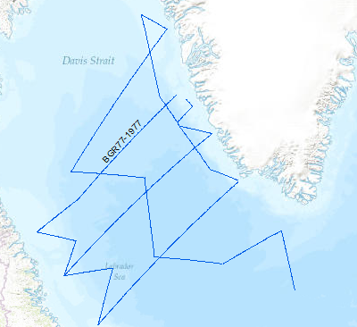
A geophysical reconnaissance survey was carried out in the Labrador Sea and Davis Strait between July and September 1977 by BGR. The data format is Society of Exploration Geophysicists SEG Y. The survey was executed on the research vessel MS Explora. The seismic, magnetic and gravity data from 5931 line-kilometers on 21 lines were recorded on magnetic tape. A 24-fold coverage technique was used with 48 seismic channels (traces), with a 2400m streamer cable, and 23.45 l airgun array. A full integrated computerized satellite navigation system (INDAS III) served as positioning system. Based on a preliminary interpretation of the seismograms, the Labrador Sea was devided into an eastern (Greenland) and western (Canadian) area, seperated by the Mid Labrador Ridge. Within the eastern part of the Labrador Sea the Pre-Cenozoic sediments show three distinct layers, traceable over the entire Greenland area of the sea. In the Cenozoic layer olisthostromes occur. The highest apparent velocity determined from sonobuoy data was 9.26 km/sec. The calculated refractor lies at a depth of approximately 13 km. The seismic section from the sediments on the Canadian side of the Labrador Sea show a uniform series of thick sediments below the Cenozoic cover. The highly disturbed basement is often masked by the multiple reflections from the seafloor. Statements about the nature and structure of the basement can only be made after processing data. Seit 1974 arbeitet die BGR an dem Schwerpunktprogramm "Geowissenschaftliche Untersuchungen im Nord-Atlantik". Die Daten liegen im Format der Society of Exploration Geophysicists SEG Y vor. In den vergangenen Jahren konzentrierten sich die Untersuchungen auf die Kontinentalränder Norwegens, Spitzbergens, Ostgrönlands und auf die Barentssee. Aus den bisherigen Ergebnissen im Nord-Atlantik ergab sich , dass bei der Rekonstruktion der geologischen Entwicklungsgeschichte des östlichen Nord-Atlantiks, mit der Grönland-und Norwegischen See auch die Labrador See in die Überlegungen einbezogen werden muß. Die Fahrt diente zur großflächigen Übersichtsvermessung der Labradorsee. Die Messungen wurden mit dem Motorschiff Explora in der Zeit vom 18.7.1977 bis zum 8.9.1977 ausgeführt.
Raumbezug
Lage der Geodaten (in WGS84)
| SW Länge/Breite | NO Länge/Breite | |
|---|---|---|
| -61.793°/55.5° | -44.611°/65.59° |
| Koordinatensystem |
|---|
Verweise und Downloads
Weitere Verweise (25)
| Identifikator des übergeordneten Metadatensatzes |
06a73c56-06a2-40d8-b806-466222b0760d |
|---|
Nutzung
| Nutzungsbedingungen |
Allgemeine Geschäftsbedingungen, siehe https://www.bgr.bund.de/AGB - General terms and conditions, see https://www.bgr.bund.de/AGB_en. Die bereitgestellten Informationen sind bei Weiterverwendung wie folgt zu zitieren: Datenquelle: BGR77, (c) BGR, Hannover, 1977 |
|---|
| Zugriffsbeschränkungen |
no limitations to public access |
|---|
Kontakt
Fachinformationen
Informationen zum Datensatz
| Identifikator |
66989e10-f8de-44bc-93cb-4871dc1e2ba4 |
|---|
| Digitale Repräsentation |
Vector |
|---|
| Fachliche Grundlage |
During the period between 18th of July to 8th of September 1977 BGR aquired seismic lines in the Labrador Sea and the Davis Strait. The lines BGR77-01, BGR77-02, BGR77-04, BGR77-05, BGR77-06, BGR77-07, BGR77-08, BGR77-09, BGR77-10, BGR77-12, BGR77-17, BGR77-17A, BGR77-18, BGR77-19, BGR77-19A, BGR77-20, BGR77-21A are processed (migrated) data. The lines BGR77-03A, BGR77-11, BGR77-14, BGR77-15, BGR77-16 and BGR77-21 are raw data. |
|---|
Zusatzinformationen
| Sprache des Datensatzes |
Englisch |
|---|
Konformität
| Spezifikation der Konformität | Spezifikationsdatum | Grad der Konformität | Geprüft mit |
|---|---|---|---|
| VERORDNUNG (EG) Nr. 1089/2010 DER KOMMISSION vom 23. November 2010 zur Durchführung der Richtlinie 2007/2/EG des Europäischen Parlaments und des Rates hinsichtlich der Interoperabilität von Geodatensätzen und -diensten | 08.12.2010 | siehe dazu die angegebene Durchführungsbestimmung |
Datenformat
| Name | Version | Kompressionstechnik | Spezifikation |
|---|---|---|---|
| Shapefile | n/a |
Informationen zum Metadatensatz
| Objekt-ID |
5feebc6e-6030-410b-8aa8-aac6ee311e52 |
|---|
| Aktualität der Metadaten |
14.11.2023 |
|---|
| Sprache Metadatensatz |
Englisch |
|---|
| Datensatz / Datenserie |
Dataset |
|---|
| XML Darstellung |
|---|
| Point of Contact (Metadatum) |
|---|
| Metadatenquelle |
GeoDaK (Datenkatalog der Bundesanstalt für Geowissenschaften und Rohstoffe)
|
|---|---|
|
ni_bubgr
|


