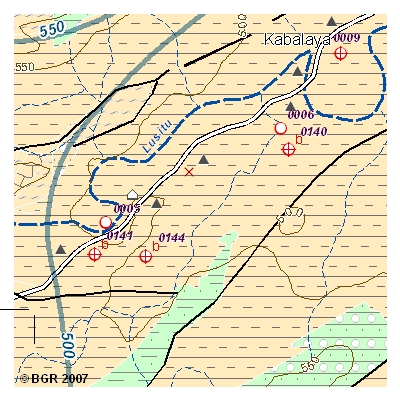
In Sambia steigt der Bedarf an Trink- und Nutzwasser ständig an. Die sambische Regierung kooperiert im Wassersektor mit der BGR als einer der Durchführungsorganisationen der bilateralen Technischen Zusammenarbeit. Innerhalb des Projektes "Grundwasserressourcen für die Südprovinz" werden Lösungskonzepte für die südlichen Landesteile erarbeitet, in denen Oberflächenwasser knapp und nicht ganzjährig verfügbar ist. Die Gewährleistung eines integrierten, nachhaltigen Managements der nationalen Grundwasserressourcen setzt voraus, dass genügend Informationen über die verfügbaren Mengen und Qualitäten sowie des Oberflächen- als auch des Grundwassers vorhanden sind. Ein Ergebnis der Datenrecherche ist die GIS-basierte Hydrogeologische Karte der Südprovinz Sambias, Blatt "Lusitu Catchment" im Maßstab 1:100.000. Die Karteninhalte setzen sich wie folgt zusammen: - Topographie; Administrative Grenzen, Verkehr, Siedlungen, Gesundheitscenter, Schulen, Relief und Gewässersystem mit Feuchtgebieten - Oberflächenwassereinzugsgebiete - Grundwassergleichen und -richtung - Aquifere - Lithologie und geologische Strukturen - Bohrlöcher, Brunnen und Quellen - Nebenkarte: Niederschlag - Indexkarte: existierende Hydrogeologische Karten der Südprovinz Sambias (Maßstab 1:100,000) Hinweis: Zusätzlich stehen 3 weitere hydrogeologische Karten der Südprovinz im Maßstab 1:250.000 und eine Karte im Maßstab 1:100.000 sowohl digital als auch gedruckt zur Verfügung. Die gedruckte Version ist nur im Gesamtpaket (4 Karten mit 2 Beiheften) erhältlich. Zambia faces an increasing demand of industrial- and drinking water. In the field Zambia faces an increasing demand of industrial- and drinking water. In the fields of water supply and management, the Zambian government cooperates with BGR as one of the implementing agencies of the German Development Cooperation and other partners. The project "Groundwater Resources for Southern Province" aims at solutions for the southern parts of the country in which surface water is scarce and only temporarily available. Accurate and updated information about quality and quantity on both surface and groundwater resources is required to regulate its use and to establish an integrated and sustainable management of the Nation’s water resources. One result of data research is reflected in the GIS-based Hydrogeological Map "Lusitu Catchment", scale 1:100,000. The contents of the maps comprise: - Topography including administrative boundaries, transport, villages, towns, health centres and schools, surface elevation - Hydrography including rivers and wetlands - Surface catchment and subcatchment boundaries - Aquifers - Groundwater elevation contours and direction of groundwater flow - Water points such as boreholes and wells and thermal springs - Lithology and geological structures (faults, etc.) - Rainfall Distribution (Insert Map) - Sheet map of available hydrogeological map sheets of Southern Province, Zambia (scale 1:250,000) Additional Information: For Southern Province 3 adjacent or overlapping hydrogeological maps at scale 1:250.000 and one map at scale 1:100,000 (digital and printed version) are available. The printed version is only available as whole package (4 maps and 2 booklets).


