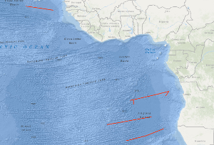
The BGR 1991 cruise with M.V. BIN HAI 511 was designed to study the variability of the oceanic crustal structure along flow-line profiles perpendicular to the ridge axis over Early Tertiary through Cretaceous old oceanic crust of the eastern Atlantic Ocean. Seismic data with a coverage of 3,000 % were acquired along four flow-line profiles with a total length of 4,194 km, and in addition 270 km of MCS data were collected during the period from 2nd October to the 3rd November 1991. The most intriguing new observation from the seismic flow-line profiles is the discovery of two huge oceanic crustal structures characterized by an internally divergent to planar pattern of reflectors having ubiquitous seaward dip. These remarkable structures were found within an about 1,300 km long oceanic crust segment of the eastern South Atlantic located between the Bode Verde Fracture zone in the north and the Rio Grande Fracture Zone in the south. These structures resemble the prominent wedges of seaward dipping reflectors on the widespread volcanic rifted continental margins described in the literature. They are interpreted to represent voluminous build-ups of layered extrusive rocks formed during three excessive episodes of volcanism that accompanied the Cretaceous opening of the South Atlantic. These episodes of excessive volcanism/magmatism are: An episode immediate prior to, and during the first stage of seafloor spreading in the South Atlantic, i.e. during about Hauterivian through about early Aptian; an episode of inferred subaerial and/or shallow marine volcanism along the central South Atlantic spreading ridge during the Albian; and an episode of inferred subaerial and/or shallow marine volcanism along the South Atlantic spreading ridge during latest Cenomanian/earliest Turonian through early Campanian. Digitalseismische Daten mit einer Überdeckung von 3.000 % sind auf der BGR-Fahrt 1991 mit M.V. BIN HAI 511 im östlichen Atlantik zwischen 12°N und 21°S auf vier flow-line Profilen mit einer Gesamtlänge von 4194 km im Zeitraum vom 02. Oktober bis zum 03. November 1991 gesammelt worden. Die interessanteste Beobachtung war der Nachweis von zwei riesigen ozeanischen Krustenstrukturen, die durch ein divergentes bis schräges und generell seewärts einfallendes Schichtungsmuster ausgezeichnet sind. Diese markanten ozeanischen Strukturen sind im 1300 km langen, ozeanischen Krustensegment des östlichen Südatlantiks beoachtet worden, das durch die Bode Verde Fracture Zone im Norden und die Rio Grande Fracture Zone im Süden begrenzt wird. Die Strukturen ähneln den Vulkanitkomplexen der vulkanischen Kontinentalränder. Sie werden deshalb von der BGR als vulkanische Extrusiva gedeutet, die während exzessiver vulkanischer Episoden in der Kreidezeit an der Spreizungszone des Südatlantiks angelegt worden sind.


