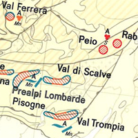
Die Internationale Karte der Eisenerz-Vorkommen in Europa 1 : 2 500 000 wurde 1977 fertig gestellt und von der BGR herausgegeben. Über 70 Geologen aus Europa, Nordafrika und dem Mittlerem Osten arbeiteten gemeinsam mit dem Redaktionsteam an der Kompilation der Karte und den Erläuterungen. Die Karte, die 42 Länder in 16 Kartenblättern abdeckt, zeigt mehr als 800 Eisenerz-Vorkommen. Alle bedeutenden Vorkommen (im Abbau oder stillgelegt) sind enthalten. Auch Vorkommen, die nur von genetischem oder historischem Interesse sind, wurden mit abgebildet. Detaillierte Informationen zur Internationalen Karte der Eisenerz-Vorkommen in Europa 1 : 2 500 000 - zu Struktur, Aufbau und Hintergrunddaten - sind in den Erläuterungen zur Karte zu finden. The International Map of the Iron Ore Deposits of Europe 1 : 2.500.000 completed in 1977 is published by the Federal Institute for Geosciences and Natural Resources (BGR) About 70 geoscientists from Europe, North Africa, Eastern Europe and Middle East collaborated with the Editorial Staff in the compilation of the map and the Editorial Notes. More than 800 iron ore deposits are represented on the map which covers 42 countries in 16 map sheets. All deposits of importance, either actually being mined or recently abandoned, are included. Deposits of only genetic or historic interest are also shown. Detailed information on the Map of Iron Ore Deposits of Europe - to its structure, arrangement and background data - can be found in the Explanatory Notes to the Map
Raumbezug
Lage der Geodaten (in WGS84)
| SW Länge/Breite | NO Länge/Breite | |
|---|---|---|
| 20.0°/28.9° | 37.54°/41.24° |
| Koordinatensystem |
Lambert Conformal Conic (Central 20°,Parallels 41°/65°), International 1909
|
|---|
Verweise und Downloads
Downloads (3)
CIGFE2500 - Blatt 15 Athinai (JPEG)
CIGFE2500 - Blatt 15 Athinai im Format JPEG (Auflösung 150 dpi)
[3.0 MB]
CIGFE2500 - Blatt 15 Athinai (PDF)
CIGFE2500 - Blatt 15 Athinai im Format Adobe Acrobat Datei (geringe Auflösung)
[2.0 MB]
CIGFE2500 - Blatt 15 Athinai (TIFF)
CIGFE2500 - Blatt 15 Athinai im Format TIFF (Auflösung 300 dpi)
[50.0 MB]
Weitere Verweise (3)
CIGFE2500 - Blatt 15 Athinai (gedruckt)
Information
CIGFE2500 - Blatt 15 Athinai im Format gedruckt, gefalzt
https://download.bgr.de/bgr/Rohstoffe/CIGFE2500/Indexkarte/CIGFE_Indexkarte.jpg
Information
Indexkarte
https://www.bgr.bund.de/DE/Themen/Sammlungen-Grundlagen/GG_geol_Info/Karten/Europa/Eisenerz-Vorkommen/eisenerz_vorkommen_node.html
Information
CIGFE2500-Internetseite - CIGFE2500-Website
| Identifikator des übergeordneten Metadatensatzes |
3F7938FA-A594-4596-A16A-8FFD2868489F |
|---|
Nutzung
| Nutzungsbedingungen |
Allgemeine Geschäftsbedingungen, s. https://www.bgr.bund.de/agb - General Terms and Conditions, s. https://www.bgr.bund.de/agb_en Preis der gedruckten Karte: 14,02 EUR (zzgl. 7% MWSt. und Versandkosten) Weitere Informationen zur Bestellung beim Internationalen Landkartenhaus siehe https://www.bgr.bund.de/produktcenter-bestellhinweis-ILH |
|---|
| Zugriffsbeschränkungen |
Es gelten keine Zugriffsbeschränkungen |
|---|
Kontakt
Fachinformationen
Informationen zum Metadatensatz
| Objekt-ID |
965D7095-BE2C-47F0-84EF-2E38DDC70CA8 |
|---|
| Aktualität der Metadaten |
02.08.2016 |
|---|
| Sprache Metadatensatz |
Deutsch |
|---|
| Datensatz / Datenserie |
Datensatz |
|---|
| XML Darstellung |
|---|
| Ansprechpartner (Metadatum) |
|---|
| Metadatenquelle |
GeoDaK (Datenkatalog der Bundesanstalt für Geowissenschaften und Rohstoffe)
|
|---|---|
|
ni_bubgr
|


