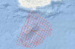
The initial study area of the cruise MSM14/2 GeoNORM (Geophysik im noerdlichen Roten Meer) was the northern Red Sea. However, because of not given research permissions from Egypt and Saudi Arabia, the study area had to be changed to the alternative study area Eratosthenes Seamount (ESM), south of Cyprus. The ESM is supposed to represent a continental fragment of the former African-Arabian Plate that is entering the subduction zone south of Cyprus i.e. the subduction turns into collision in the area of the ESM. This changed the entire tectonic setting in the Eastern Mediterranean. Therefore, the tectonic evolution of the area is rather complex with phases of extension, subduction, compression, salt tectonics and gravitational processes and not comprehensively understood. Because of the isolation of the ESM as a continental fragment this region is an ideal spot to investigate the transition from regular subduction to continental collision and its associated tectonic processes i.e. faults were activated or reactivated, transform motion has to be compensated, the overriding plate has been elevated. This impacts the ongoing geological and tectonic processes in this region but also influences the social and economic life in the Eastern Mediterranean as earthquakes and submarine landslides are possible geohazards and the entering of the ESM to the subduction trench alters the thermal history of the adjacent sedimentary basins significantly what should have an influence on the maturity processes within the source rock sediments and new faults open new migration paths for hydrocarbon fluids or gases. Das ursprünglich geplante Untersuchungsgebiet der Fahrt MSM14/2 (Akronym GeoNORM, Geophysík im noerdlichen Roten Meer) befand sich im nördlichen Roten Meer. Aufgrund von nicht erteilten Forschungsgenehmigungen seitens Ägyptens und Saudi Arabiens wurde beschlossen, das alternative Forschungsgebiet "Eratosthenes Seamount" (ESM) südlich von Zypern anzufahren. Der ESM besteht mit großer Wahrscheinlichkeit aus einem kontinentalen Fragment der früheren Afrikanisch-Arabischen Platte. Dieses Fragment tritt momentan in die Subduktionszone südlich Zyperns ein, d.h. die Subduktion wandelt sich in eine Kontinent-Kontinent Kollision. Das beeinflusst das gesamte tektonische Regime im östlichen Mittelmeer-Raum, der durch diese Kollision erheblich an Komplexität gewinnt unter anderem durch Phasen der Extension, Kollision, Subduktion, als auch durch Salz-Tektonik und Gravitationsprozesse. Aufgrund seiner isolierten Lage als vorgeschobenes kontinentales Fragment bildet der ESM ein ideales Ziel um die Übergangsprozesse zu studieren, die beim Übergang von normaler Subduktion zu Kontinent-Kontinent Kollision entstehen, wie beispielsweise die Entstehung neuer Störungen, die Reaktivierung alter Störungen, die Kompensierung von Transformbewegungen, das Anheben der sub(ob)duzierten Platte. Das beein?usst nicht nur die aktuellen geologischen tektonischen Prozesse im östlichen Mittelmeerraum, sondern auch das soziale und wirtschaftliche Leben in dieser Region, denn einerseits bilden Erdbeben und submarine Hangrutschungen ein potentielles Georisiko und andererseits hat die Subduktion / Kollision Ein?uss auf das angrenzende Sedimentbecken (Levante-Becken) bezüglich des Wärmestromflusses und damit auf die Maturitätseigenschaften der möglichen Muttergesteine für Kohlenwasserstoffvorkommen und auch auf mögliche Migrationswege der flüssigen oder gasförmigen Kohlenwasserstoffe aufgrund neu gebildeter oder reaktivierter Störungen.
Raumbezug
Lage der Geodaten (in WGS84)
| SW Länge/Breite | NO Länge/Breite | |
|---|---|---|
| 32.2°/32.94° | 33.76°/34.54° |
| Koordinatensystem |
|---|
Verweise und Downloads
Weitere Verweise (31)
| Identifikator des übergeordneten Metadatensatzes |
06a73c56-06a2-40d8-b806-466222b0760d |
|---|
Nutzung
| Nutzungsbedingungen |
Allgemeine Geschäftsbedingungen, siehe http://www.bgr.bund.de/AGB - General terms and conditions, see http://www.bgr.bund.de/AGB_en. Die bereitgestellten Informationen sind bei Weiterverwendung wie folgt zu zitieren: Datenquelle: MSM14/2 2010, (c) BGR, Hannover, 2018 |
|---|
| Zugriffsbeschränkungen |
no limitations to public access |
|---|
Kontakt
Fachinformationen
Informationen zum Datensatz
| Identifikator |
a9665b1b-1110-e2bf-f1a3-bab04397faac |
|---|
| Digitale Repräsentation |
Vector |
|---|
| Fachliche Grundlage |
During the period from the 18th January to the 25th February 2010 BGR acquired seismic lines south of Cyprus in the Eastern Basin of the Mediterranean Sea. The lines BGR10-101a, BGR10-104a, BGR10-112a, BGR10-118a, BGR10-119, BGR10-122v, BGR10-131, BGR10-131a, BGR10-132, BGR10-133, BGR10-134, BGR10-135, BGR10-136, BGR10-137, BGR10-138 and BGR10-138a consist of raw data, the line BGR10-102 consist of stacked data and the lines BGR10-101, BGR10-103, BGR10-104, BGR10-105, BGR10-106, BGR10-107, BGR10-108, BGR10-109, BGR10-110, BGR10-111, BGR10-112, BGR10-113, BGR10-114, BGR10-115, BGR10-116, BGR10-117, BGR10-118,BGR10-119-2, BGR10-120-2, BGR10-121-2, BGR10-122-2, BGR10-123, BGR10-124, BGR10-125, BGR10-126, BGR10-127, BGR10-128, BGR10-129 and BGR10-130 are migrated data. |
|---|
Zusatzinformationen
| Sprache des Datensatzes |
Englisch |
|---|
Konformität
| Spezifikation der Konformität | Spezifikationsdatum | Grad der Konformität | Geprüft mit |
|---|---|---|---|
| VERORDNUNG (EG) Nr. 1089/2010 DER KOMMISSION vom 23. November 2010 zur Durchführung der Richtlinie 2007/2/EG des Europäischen Parlaments und des Rates hinsichtlich der Interoperabilität von Geodatensätzen und -diensten | 08.12.2010 | siehe dazu die angegebene Durchführungsbestimmung |
Datenformat
| Name | Version | Kompressionstechnik | Spezifikation |
|---|---|---|---|
| Shapefile | n/a |
Schlagworte
| INSPIRE-Themen | Geology |
| GEMET-Concepts | geophysics Geophysik raw material Rohstoff |
| ISO-Themenkategorien | Geoscientific Information |
| Suchbegriffe | Cyprus Eastern Mediterranean Sea Eratosthenes Seamount Marine geology Meeresgeologie Seismics Seismik Two-dimensional seismic reflection zweidimensionale Reflektionsseismik Zypern |
Informationen zum Metadatensatz
| Objekt-ID |
a65f2630-48dd-4c51-908b-4f14ca4b89c4 |
|---|
| Aktualität der Metadaten |
14.11.2023 |
|---|
| Sprache Metadatensatz |
Englisch |
|---|
| Datensatz / Datenserie |
Dataset |
|---|
| XML Darstellung |
|---|
| Point of Contact (Metadatum) |
|---|
| Metadatenquelle |
GeoDaK (Datenkatalog der Bundesanstalt für Geowissenschaften und Rohstoffe)
|
|---|---|
|
ni_bubgr
|


