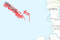
The previous BGR-cruises with RV AURELIA in 2003 and 2004 and RV HEINCKE in 2005 and RV ALKOR in 2006 were designed to collect a grid of seismic MCS-data which should enable us to get a high-resolution overview over the upper 1-2 s TWT of the sediments of the German North Sea sector. The data format is Society of Exploration Geophysicists SEG Y. The aim of this cruise was a detailed survey in the north westernmost area of the German EEZ (exclusive economic zone), the so-called ‘Entenschnabel’ and additionally a mapping of special glacial structures off Sylt Island. The cruise was subdivided into two Legs. One outreaching additional aim was to extend the results from the previous cruises for the Late Tertiary and Quaternary sedimentary evolution into the ‘Entenschnabel’-area which was virtually unexplored by systematic shallow high-resolution seismics. During Leg 1 the BGR high-resolution multichannel seismic reflection system consisting of a GI-Gun (0.8 l) and a 500 m streamer with 36 channels and a shallow swath bathymetric system, type SIMRAD EM1200 by Kongsberg, Bergen, Norway were used. While the BGR-seismic system was used to observe the shallow subsurface down to 2 s TWT penetration depth, the swath bathymetric system was used to identify possible pockmark locations as well as sampling positions for the deployment of the BGR vibration corer during the succeeding Leg 2. All seismic records were processed onboard for the quality control and for a first interpretation loaded into GEOQUEST. Im Gegensatz zu den vorangegangen BGR-Fahrten mit FS AURELIA in 2003 und 2004 sowie FS HEINCKE in 2005 und FS ALKOR in 2006, die zum größten Teil Übersichtsvermessungen dienten, waren die Ziele dieser Fahrt mit RV FRANKLIN konzentrierte Spezialvermessungen im Bereich des so genannten ‚Entenschnabels’, dem äußersten Nord-westlichen Bereich der deutschen AWZ (Ausschließliche Wirtschaftszone), sowie Untersuchungen hinsichtlich der Verbreitung von Glazialstrukturen vor Sylt. Die Daten liegen im Format der Society of Exploration Geophysicists SEG Y vor. Die Fahrt unterteilte sich in zwei Abschnitte. Es sollte weiterführend die spättertiäre und quartäre Entwicklung des deutschen Nordsee-Sektors, aufbauend auf den Ergebnissen der vorangegangenen Expeditionen, in den bisher flachseismisch weitgehend unerforschten ‚Entenschnabel’ hineingetragen und weiter systematisch erkundet werden. Während Leg 1 sollte vorwiegend die BGR-eigene Mehrkanalseismik (MCS) - adaptiert für flachgründige Vermessungen - unterstützt vom bordeigenen Flachwasser-Fächerecholot zum Einsatz kommen. Leg 2 sollte sich dann der eingehenden geologischen und geochemischen Beprobungen (Einsatz von Vibrocorer, MUC und Schwerelot), sowie höchstauflösenden MCS-Vermessungen widmen. Auch diese Untersuchungen wurden u.a. mit sogenannten ‚Matratzenfahrten’ des Flachwasser- Fächerecholots ergänzt bzw. erweitert. Während des ersten Abschnitts der Fahrt wurden insgesamt ca. 1500 km qualitativ hochwertiger MCS-Daten erfasst und gleichzeitig mit dem Fächerecholot vermessen. Eingesetzt wurde das BGR-eigene hochauflösende System, bestehend aus einer GI-Gun (0.8 l) und einem 500 m langen Streamer mit 36 Kanälen und ein Flachwasser-Fächerecholot Typ SIMRAD EM 1200 der Fa. Kongsberg, Bergen, Norwegen. Während das BGR-System zur regelmäßigen Erfassung des gesamten flachen Oberbaus bis 2 s TWT Eindringtiefe eingesetzt wurde, sollte das Flachwasserecholot vor allem zur Lokalisation von Anomalien in der Meeresbodentopographie (z.B. die oben erwähnten, Pockmarks’), als auch zur Lokalisation von Beprobungspunkten für den Einsatz des BGR Vibrations-kerngeräts im anschließenden Leg 2 dienen. Alle seismischen Profile wurden zur Qualitätskontrolle und für eine erste Auswertung und Interpretation in GeoQuest geladen.
Raumbezug
Lage der Geodaten (in WGS84)
| SW Länge/Breite | NO Länge/Breite | |
|---|---|---|
| 3.163°/54.704° | 6.221°/55.969° |
| Koordinatensystem |
|---|
Verweise und Downloads
Weitere Verweise (34)
http://www.geo-seas.eu/v_cdi_v3/print_ajax.asp?n_code=1302042
Information
Profile BGR07-101
http://www.geo-seas.eu/v_cdi_v3/print_ajax.asp?n_code=1302043
Information
Profile BGR07-102
http://www.geo-seas.eu/v_cdi_v3/print_ajax.asp?n_code=1302044
Information
Profile BGR07-103
http://www.geo-seas.eu/v_cdi_v3/print_ajax.asp?n_code=1302045
Information
Profile BGR07-104
http://www.geo-seas.eu/v_cdi_v3/print_ajax.asp?n_code=1302046
Information
Profile BGR07-105
http://www.geo-seas.eu/v_cdi_v3/print_ajax.asp?n_code=1302047
Information
Profile BGR07-106
http://www.geo-seas.eu/v_cdi_v3/print_ajax.asp?n_code=1302048
Information
Profile BGR07-107A
http://www.geo-seas.eu/v_cdi_v3/print_ajax.asp?n_code=1302049
Information
Profile BGR07-107
http://www.geo-seas.eu/v_cdi_v3/print_ajax.asp?n_code=1302050
Information
Profile BGR07-108
http://www.geo-seas.eu/v_cdi_v3/print_ajax.asp?n_code=1302051
Information
Profile BGR07-109
http://www.geo-seas.eu/v_cdi_v3/print_ajax.asp?n_code=1302052
Information
Profile BGR07-110
http://www.geo-seas.eu/v_cdi_v3/print_ajax.asp?n_code=1302053
Information
Profile BGR07-111
http://www.geo-seas.eu/v_cdi_v3/print_ajax.asp?n_code=1302054
Information
Profile BGR07-112
http://www.geo-seas.eu/v_cdi_v3/print_ajax.asp?n_code=1302055
Information
Profile BGR07-113
http://www.geo-seas.eu/v_cdi_v3/print_ajax.asp?n_code=1302056
Information
Profile BGR07-114
http://www.geo-seas.eu/v_cdi_v3/print_ajax.asp?n_code=1302057
Information
Profile BGR07-115
http://www.geo-seas.eu/v_cdi_v3/print_ajax.asp?n_code=1302058
Information
Profile BGR07-116
http://www.geo-seas.eu/v_cdi_v3/print_ajax.asp?n_code=1302059
Information
Profile BGR07-117A
http://www.geo-seas.eu/v_cdi_v3/print_ajax.asp?n_code=1302060
Information
Profile BGR07-117
http://www.geo-seas.eu/v_cdi_v3/print_ajax.asp?n_code=1302061
Information
Profile BGR07-118
http://www.geo-seas.eu/v_cdi_v3/print_ajax.asp?n_code=1302062
Information
Profile BGR07-119
http://www.geo-seas.eu/v_cdi_v3/print_ajax.asp?n_code=1302063
Information
Profile BGR07-120
http://www.geo-seas.eu/v_cdi_v3/print_ajax.asp?n_code=1302064
Information
Profile BGR07-121
http://www.geo-seas.eu/v_cdi_v3/print_ajax.asp?n_code=1302065
Information
Profile BGR07-122A
http://www.geo-seas.eu/v_cdi_v3/print_ajax.asp?n_code=1302066
Information
Profile BGR07-122
http://www.geo-seas.eu/v_cdi_v3/print_ajax.asp?n_code=1302067
Information
Profile BGR07-123
http://www.geo-seas.eu/v_cdi_v3/print_ajax.asp?n_code=1302068
Information
Profile BGR07-124
http://www.geo-seas.eu/v_cdi_v3/print_ajax.asp?n_code=1302069
Information
Profile BGR07-125
http://www.geo-seas.eu/v_cdi_v3/print_ajax.asp?n_code=1302070
Information
Profile BGR07-126
http://www.geo-seas.eu/v_cdi_v3/print_ajax.asp?n_code=1302071
Information
Profile BGR07-127
http://www.geo-seas.eu/v_cdi_v3/print_ajax.asp?n_code=1302072
Information
Profile BGR07-128
http://www.geo-seas.eu/v_cdi_v3/print_ajax.asp?n_code=1302073
Information
Profile BGR07-129
http://www.geo-seas.eu/v_cdi_v3/print_ajax.asp?n_code=1302074
Information
Profile BGR07-130
https://services.bgr.de/geophysik/mssp
Information
Karte im BGR-Geoviewer
| Identifikator des übergeordneten Metadatensatzes |
06a73c56-06a2-40d8-b806-466222b0760d |
|---|
Nutzung
| Nutzungsbedingungen |
Allgemeine Geschäftsbedingungen, siehe https://www.bgr.bund.de/AGB - General terms and conditions, see https://www.bgr.bund.de/AGB_en. Die bereitgestellten Informationen sind bei Weiterverwendung wie folgt zu zitieren: Datenquelle: BGR07, (c) BGR, Hannover, 2007 |
|---|
| Zugriffsbeschränkungen |
no limitations to public access |
|---|
Kontakt
Fachinformationen
Informationen zum Datensatz
| Identifikator |
15ef5959-adb4-45fa-ba10-bc76f8c1c1e7 |
|---|
| Digitale Repräsentation |
Vector |
|---|
| Fachliche Grundlage |
During the period from 23rd of June to 28th of July 2007 BGR aquired seismic lines in the Central North Sea. All lines are processed (migrated) data. |
|---|
Zusatzinformationen
| Sprache des Datensatzes |
Englisch |
|---|
Konformität
| Spezifikation der Konformität | Spezifikationsdatum | Grad der Konformität | Geprüft mit |
|---|---|---|---|
| VERORDNUNG (EG) Nr. 1089/2010 DER KOMMISSION vom 23. November 2010 zur Durchführung der Richtlinie 2007/2/EG des Europäischen Parlaments und des Rates hinsichtlich der Interoperabilität von Geodatensätzen und -diensten | 08.12.2010 | siehe dazu die angegebene Durchführungsbestimmung |
Datenformat
| Name | Version | Kompressionstechnik | Spezifikation |
|---|---|---|---|
| Shapefile | n/a |
Schlagworte
| INSPIRE-Themen | Geology |
| GEMET-Concepts | geophysics Geophysik marine geology Meeresgeologie raw material Rohstoff |
| ISO-Themenkategorien | Geoscientific Information |
| Suchbegriffe | Deutsche AWZ GeolDG German EEZ MSSP Nordsee North Sea seismics Seismik two-dimensional seismic reflection zweidimensionale Reflektionsseismik |
Informationen zum Metadatensatz
| Objekt-ID |
b5441f9c-7e10-493d-a6de-3286925546d4 |
|---|
| Aktualität der Metadaten |
07.04.2025 |
|---|
| Sprache Metadatensatz |
Englisch |
|---|
| Datensatz / Datenserie |
Dataset |
|---|
| XML Darstellung |
|---|
| Point of Contact (Metadatum) |
|---|
| Metadatenquelle |
GeoDaK (Datenkatalog der Bundesanstalt für Geowissenschaften und Rohstoffe)
|
|---|---|
|
ni_bubgr
|


