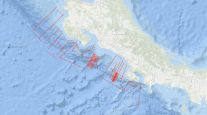
Between 08.11.1999 and 02.12.1999 the active convergent margin off Costa Rica was investigated using the S/V Professor Polshkov. The cruise had three scientific targets. Several seismic profiles in the dip-direction of the subduction zone were acquired to map the general variability of the accretionary wedge. Near the Jaco Scarp, a dense net of seismic profiles using a smaller seismic source should deliver information about the amount of gas hydrates within the shallow sub-surface. In an area of this wedge south of the Quepos Plateau densely spaced seismic lines were measured to prepare an ODP campaign (which was finished in 2011 as IODP Expedition 334). Zwischen dem 08.11.1999 und 02.12.1999 wurde der aktive Kontinentrand vor Costa Rica mit dem Seismik-Schiff Professor Polshkov untersucht. Diese Fahrt hatte drei wissenschaftliche Ziele. Einerseits sollten mehrere Profile senkrecht zum Rand die generelle Variabilität des Akkretionskeils abbilden. In der Nähe des Jaco Scarps sollte ein dichtes Netz seismischer Profile in Verbindung mit einer hochfrequenten seismischen Quelle Informationen über die Gashydrat-Verteilung im Sediment liefern. Im Bereich südlich des Quepos-Plateaus sollten mehrere engmaschige Profile zur Vorbereitung eine ODP-Kampagne dienen – diese wurde 2011 als IOPD Expedition 334 durchgeführt.
Raumbezug
Lage der Geodaten (in WGS84)
| SW Länge/Breite | NO Länge/Breite | |
|---|---|---|
| -86.885°/7.45° | -83.225°/10.908° |
| Koordinatensystem |
|---|
Verweise und Downloads
Weitere Verweise (60)
http://www.geo-seas.eu/v_cdi_v3/print_ajax.asp?n_code=1299063
Information
Profile BGR99-01
http://www.geo-seas.eu/v_cdi_v3/print_ajax.asp?n_code=1299064
Information
Profile BGR99-02
http://www.geo-seas.eu/v_cdi_v3/print_ajax.asp?n_code=1299065
Information
Profile BGR99-03
http://www.geo-seas.eu/v_cdi_v3/print_ajax.asp?n_code=1299066
Information
Profile BGR99-04
http://www.geo-seas.eu/v_cdi_v3/print_ajax.asp?n_code=1299067
Information
Profile BGR99-05
http://www.geo-seas.eu/v_cdi_v3/print_ajax.asp?n_code=1299068
Information
Profile BGR99-06
http://www.geo-seas.eu/v_cdi_v3/print_ajax.asp?n_code=1299069
Information
Profile BGR99-07
http://www.geo-seas.eu/v_cdi_v3/print_ajax.asp?n_code=1299070
Information
Profile BGR99-08
http://www.geo-seas.eu/v_cdi_v3/print_ajax.asp?n_code=1299071
Information
Profile BGR99-09
http://www.geo-seas.eu/v_cdi_v3/print_ajax.asp?n_code=1299072
Information
Profile BGR99-10
http://www.geo-seas.eu/v_cdi_v3/print_ajax.asp?n_code=1299073
Information
Profile BGR99-11
http://www.geo-seas.eu/v_cdi_v3/print_ajax.asp?n_code=1299074
Information
Profile BGR99-12A
http://www.geo-seas.eu/v_cdi_v3/print_ajax.asp?n_code=1299075
Information
Profile BGR99-12
http://www.geo-seas.eu/v_cdi_v3/print_ajax.asp?n_code=1299076
Information
Profile BGR99-13
http://www.geo-seas.eu/v_cdi_v3/print_ajax.asp?n_code=1299077
Information
Profile BGR99-14
http://www.geo-seas.eu/v_cdi_v3/print_ajax.asp?n_code=1299078
Information
Profile BGR99-15
http://www.geo-seas.eu/v_cdi_v3/print_ajax.asp?n_code=1299079
Information
Profile BGR99-16A
http://www.geo-seas.eu/v_cdi_v3/print_ajax.asp?n_code=1299080
Information
Profile BGR99-16
http://www.geo-seas.eu/v_cdi_v3/print_ajax.asp?n_code=1299081
Information
Profile BGR99-17
http://www.geo-seas.eu/v_cdi_v3/print_ajax.asp?n_code=1299082
Information
Profile BGR99-18
http://www.geo-seas.eu/v_cdi_v3/print_ajax.asp?n_code=1299083
Information
Profile BGR99-19
http://www.geo-seas.eu/v_cdi_v3/print_ajax.asp?n_code=1299084
Information
Profile BGR99-20
http://www.geo-seas.eu/v_cdi_v3/print_ajax.asp?n_code=1299085
Information
Profile BGR99-21
http://www.geo-seas.eu/v_cdi_v3/print_ajax.asp?n_code=1299086
Information
Profile BGR99-22
http://www.geo-seas.eu/v_cdi_v3/print_ajax.asp?n_code=1299087
Information
Profile BGR99-23
http://www.geo-seas.eu/v_cdi_v3/print_ajax.asp?n_code=1299088
Information
Profile BGR99-39
http://www.geo-seas.eu/v_cdi_v3/print_ajax.asp?n_code=1299089
Information
Profile BGR99-40
http://www.geo-seas.eu/v_cdi_v3/print_ajax.asp?n_code=1299090
Information
Profile BGR99-41
http://www.geo-seas.eu/v_cdi_v3/print_ajax.asp?n_code=1299091
Information
Profile BGR99-42
http://www.geo-seas.eu/v_cdi_v3/print_ajax.asp?n_code=1299092
Information
Profile BGR99-43
http://www.geo-seas.eu/v_cdi_v3/print_ajax.asp?n_code=1299093
Information
Profile BGR99-44
http://www.geo-seas.eu/v_cdi_v3/print_ajax.asp?n_code=1299094
Information
Profile BGR99-45
http://www.geo-seas.eu/v_cdi_v3/print_ajax.asp?n_code=1299095
Information
Profile BGR99-46A
http://www.geo-seas.eu/v_cdi_v3/print_ajax.asp?n_code=1299096
Information
Profile BGR99-46
http://www.geo-seas.eu/v_cdi_v3/print_ajax.asp?n_code=1299097
Information
Profile BGR99-47A
http://www.geo-seas.eu/v_cdi_v3/print_ajax.asp?n_code=1299098
Information
Profile BGR99-47
http://www.geo-seas.eu/v_cdi_v3/print_ajax.asp?n_code=1299099
Information
Profile BGR99-48
http://www.geo-seas.eu/v_cdi_v3/print_ajax.asp?n_code=1299100
Information
Profile BGR99-49A
http://www.geo-seas.eu/v_cdi_v3/print_ajax.asp?n_code=1299101
Information
Profile BGR99-50
http://www.geo-seas.eu/v_cdi_v3/print_ajax.asp?n_code=1299102
Information
Profile BGR99-51
http://www.geo-seas.eu/v_cdi_v3/print_ajax.asp?n_code=1299103
Information
Profile BGR99-52
http://www.geo-seas.eu/v_cdi_v3/print_ajax.asp?n_code=1299104
Information
Profile BGR99-53
http://www.geo-seas.eu/v_cdi_v3/print_ajax.asp?n_code=1299105
Information
Profile BGR99-54
http://www.geo-seas.eu/v_cdi_v3/print_ajax.asp?n_code=1299106
Information
Profile BGR99-55
http://www.geo-seas.eu/v_cdi_v3/print_ajax.asp?n_code=1299107
Information
Profile BGR99-56
http://www.geo-seas.eu/v_cdi_v3/print_ajax.asp?n_code=1299108
Information
Profile BGR99-57
http://www.geo-seas.eu/v_cdi_v3/print_ajax.asp?n_code=1299109
Information
Profile BGR99-58A
http://www.geo-seas.eu/v_cdi_v3/print_ajax.asp?n_code=1299110
Information
Profile BGR99-58
http://www.geo-seas.eu/v_cdi_v3/print_ajax.asp?n_code=1299111
Information
Profile BGR99-59
http://www.geo-seas.eu/v_cdi_v3/print_ajax.asp?n_code=1299112
Information
Profile BGR99-60
http://www.geo-seas.eu/v_cdi_v3/print_ajax.asp?n_code=1299113
Information
Profile BGR99-61
http://www.geo-seas.eu/v_cdi_v3/print_ajax.asp?n_code=1299114
Information
Profile BGR99-62
http://www.geo-seas.eu/v_cdi_v3/print_ajax.asp?n_code=1299115
Information
Profile BGR99-63
http://www.geo-seas.eu/v_cdi_v3/print_ajax.asp?n_code=1299116
Information
Profile BGR99-64
http://www.geo-seas.eu/v_cdi_v3/print_ajax.asp?n_code=1299117
Information
Profile BGR99-65
http://www.geo-seas.eu/v_cdi_v3/print_ajax.asp?n_code=1299118
Information
Profile BGR99-66
http://www.geo-seas.eu/v_cdi_v3/print_ajax.asp?n_code=1299119
Information
Profile BGR99-67
http://www.geo-seas.eu/v_cdi_v3/print_ajax.asp?n_code=1299120
Information
Profile BGR99-68
http://www.geo-seas.eu/v_cdi_v3/print_ajax.asp?n_code=1299121
Information
Profile BGR99-69
https://services.bgr.de/geophysik/mssp
Information
Karte im BGR-Geoviewer
| Identifikator des übergeordneten Metadatensatzes |
06a73c56-06a2-40d8-b806-466222b0760d |
|---|
Nutzung
| Nutzungsbedingungen |
Allgemeine Geschäftsbedingungen, siehe http://www.bgr.bund.de/AGB - General terms and conditions, see http://www.bgr.bund.de/AGB_en. Die bereitgestellten Informationen sind bei Weiterverwendung wie folgt zu zitieren: Datenquelle: BGR99 1999, (c) BGR, Hannover, 2018 |
|---|
| Zugriffsbeschränkungen |
no limitations to public access |
|---|
Kontakt
Fachinformationen
Informationen zum Datensatz
| Identifikator |
313ce6c8-1aed-1ea5-87c5-61c032a1c4bf |
|---|
| Digitale Repräsentation |
Vector |
|---|
| Fachliche Grundlage |
During the period from 8th November to 2nd December 1999 BGR acquired seismic lines off the Pacific coast of Costa Rica. All lines BGR99-01 to BGR99-23 and BGR99-39 to BGR99-69 consist of stacked data. |
|---|
Zusatzinformationen
| Sprache des Datensatzes |
Englisch |
|---|
Konformität
| Spezifikation der Konformität | Spezifikationsdatum | Grad der Konformität | Geprüft mit |
|---|---|---|---|
| VERORDNUNG (EG) Nr. 1089/2010 DER KOMMISSION vom 23. November 2010 zur Durchführung der Richtlinie 2007/2/EG des Europäischen Parlaments und des Rates hinsichtlich der Interoperabilität von Geodatensätzen und -diensten | 08.12.2010 | siehe dazu die angegebene Durchführungsbestimmung |
Datenformat
| Name | Version | Kompressionstechnik | Spezifikation |
|---|---|---|---|
| Shapefile | n/a |
Schlagworte
| INSPIRE-Themen | Geology |
| GEMET-Concepts | geophysics Geophysik raw material Rohstoff |
| ISO-Themenkategorien | Geoscientific Information |
| Suchbegriffe | Costa Rica Marine geology Meeresgeologie Nordost-Pazifik Northeast Pacific Ocean Seismics Seismik Two-dimensional seismic reflection zweidimensionale Reflektionsseismik |
Informationen zum Metadatensatz
| Objekt-ID |
b61ec9c1-0d1b-408f-8c13-aedb8a028b75 |
|---|
| Aktualität der Metadaten |
16.11.2023 |
|---|
| Sprache Metadatensatz |
Englisch |
|---|
| Datensatz / Datenserie |
Dataset |
|---|
| XML Darstellung |
|---|
| Point of Contact (Metadatum) |
|---|
| Metadatenquelle |
GeoDaK (Datenkatalog der Bundesanstalt für Geowissenschaften und Rohstoffe)
|
|---|---|
|
ni_bubgr
|


