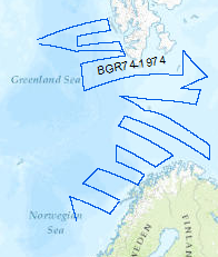
Reconnaissance surveys were carried out in 1974 within the framework of the BGR program "Geoscientific studies in the North Atlantic". The areas covered were the continental margin of Spitsbergen, the Barents Sea and the Norwegian continental margin. On the R/V LONGVA (10th August, 1974 - 10th September, 1974) multichannel seismic measurements were carried out on 40 lines with a total length of 8,091 km. The data format is Society of Exploration Geophysicists SEG Y. Im Rahmen des BGR-Programms „Geowissenschaftliche Erkundung des Nord-Atlantik“ wurden seismische Messungen am Kontinentrand Spitsbergens, in der Barentssee und am norwegischen Kontinentrand durchgeführt. In der Zeit vom 10.08.1974 bis 10.09.1974 wurden mit FS Longva 40 seismische Linien mit einer Länge von 8091 km vermessen. Die Daten liegen im SEG-Y Format vor.
Raumbezug
Lage der Geodaten (in WGS84)
| SW Länge/Breite | NO Länge/Breite | |
|---|---|---|
| 0.106°/66.302° | 31.466°/78.505° |
| Koordinatensystem |
|---|
Verweise und Downloads
Weitere Verweise (41)
| Identifikator des übergeordneten Metadatensatzes |
06a73c56-06a2-40d8-b806-466222b0760d |
|---|
Nutzung
| Nutzungsbedingungen |
Allgemeine Geschäftsbedingungen, siehe https://www.bgr.bund.de/AGB - General terms and conditions, see https://www.bgr.bund.de/AGB_en. Die bereitgestellten Informationen sind bei Weiterverwendung wie folgt zu zitieren: Datenquelle: BGR 74, (c) BGR, Hannover, 1974 |
|---|
| Zugriffsbeschränkungen |
no limitations to public access |
|---|
Kontakt
Fachinformationen
Informationen zum Datensatz
| Identifikator |
fd17dde2-e3dc-41e0-9559-e84d80330efa |
|---|
| Digitale Repräsentation |
Vector |
|---|
| Fachliche Grundlage |
During the period from 10th of August to 10th of September 1974 BGR aquired seismic lines in the North Atlantic. The lines BGR74-01, BGR74-02, BGR74-03, BGR74-04, BGR74-05, BGR74-06, BGR74-07, BGR74-08, BGR74-09, BGR74-10, BGR74-11, BGR74-12, BGR74-12B, BGR74-14, BGR74-14B, BGR74-15, BGR74-16, BGR74-16B, BGR74-16C, , BGR74-17, BGR74-17B, BGR74-18, BGR74-19, BGR74-20, BGR74-21, BGR74-22, BGR74-23, BGR74-25, BGR74-25B, BGR74-26, BGR74-27, BGR74-27B, BGR74-29, BGR74-30, BGR74-31, BGR74-32 are processed (stack) data. The lines BGR74-06A, BGR74-13, BGR74-24, BGR74-28 are raw data. |
|---|
Zusatzinformationen
| Sprache des Datensatzes |
Englisch |
|---|
Konformität
| Spezifikation der Konformität | Spezifikationsdatum | Grad der Konformität | Geprüft mit |
|---|---|---|---|
| VERORDNUNG (EG) Nr. 1089/2010 DER KOMMISSION vom 23. November 2010 zur Durchführung der Richtlinie 2007/2/EG des Europäischen Parlaments und des Rates hinsichtlich der Interoperabilität von Geodatensätzen und -diensten | 08.12.2010 | siehe dazu die angegebene Durchführungsbestimmung |
Datenformat
| Name | Version | Kompressionstechnik | Spezifikation |
|---|---|---|---|
| Shapefile | n/a |
Informationen zum Metadatensatz
| Objekt-ID |
bab56949-fd5f-46a0-ac7d-f60fb6acce57 |
|---|
| Aktualität der Metadaten |
14.11.2023 |
|---|
| Sprache Metadatensatz |
Englisch |
|---|
| Datensatz / Datenserie |
Dataset |
|---|
| XML Darstellung |
|---|
| Point of Contact (Metadatum) |
|---|
| Metadatenquelle |
GeoDaK (Datenkatalog der Bundesanstalt für Geowissenschaften und Rohstoffe)
|
|---|---|
|
ni_bubgr
|


