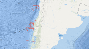
Within the frame of the comprehensive SPOC project (Subduction Processes off Chile) the SONNE cruises SO161 Leg 2 and 3 have been conducted between October 16th and November 29th, 2001, off central Chile between 28° and 44° S. In that period some 5,300 km were surveyed with multichannel seismic (MCS) reflection, magnetic, gravity, high-resolution bathymetric and echographic methods. In addition, approximately 3,900 km were surveyed with the same spectrum of methods but without MCS. The total number of 2D profiles was 48. Target was the variation of the subduction properties between the convergent oceanic Nazca and continental Southamerica plates and the different conditions that might influence the subduction process as there are: (1) age of the oceanic crust, (2) its structure and composition, (3) its sedimentary cover, (4) its thermal state, (5) the subduction angle and obliquity, and (6) the terrigenous sediment afflux from the continent. Furthermore, special focus was given to the subduction front, the subduction interface, the structure of the slope as well as to the forearc basin structure and history, and the general distribution of gas hydrate indicating bottom simulating reflectors (BSR's). The results are to be compared with previous studies of the Chilean active margin, e.g. CONDOR (SO 101 and 103) and CINCA (SO 104). The SPOC target area was subdivided into three sub-areas A,B and C. One area was chosen for a detailed survey by aid of a narrowly spaced grid and for a close link with a lot of partners. This area is characterized by a distinctly different margin type south of it is assumed. Moreover, the subducting portion of the aseismic Juan Fernandez Ridge is located in that area representing another important target of the survey. Advantageous conditions enabled the survey of an east-west profile south of Chiloé Island, providing a section through the submerged coastal Cordillera into the flooded longitudinal valley. Some results of Leg 2 and 3 are: In all areas A, B and C no subduction bulge (outer high) in the oceanic crust was visible perhaps due to the shortness of the profiles. The sedimentary cover of the oceanic crust is exceptionally thin, and the crustal thickness is generally quite "normal" with around 7 km derived from relatively weak Moho reflections. In area B a so far magnetically unmapped region was filled providing reliable ages of the oceanic crust, and suggesting that the Challenger Fracture Zone abruptly terminates west of the area of investigation. The survey in area C yielded valuable information on the trench morphology. The so far unique MCS profile south of Chiloé island shows a very wide trench and allows to extrapolate the general conditions encountered an area A southward to approximately 44° S. It can be stated that the situation is in sharp contrast to the basin structures detected by industry profiles further north in the Golfo de Corcovado. Im Rahmen des weit gespannten SPOC-Projektes (Subduction Processes off Chile) wurden zwischen dem 16.10. und 29.11.2001 vor Zentralchile zwischen 28° und 44°S die SONNE-Fahrten SO161 Leg 2 und 3 durchgeführt. In diesem Zeitraum wurden etwa 5.300 km mit vielkanal-/reflexionsseismischen (MCS), magnetischen, gravimetrischen, hochauflösenden bathymetrischen und echographischen Methoden vermessen. Hinzu kamen etwa 3.900 km mit denselben Verfahren, jedoch ohne MCS. Die Gesamtzahl der 2D-Profile betrug 48. Auf vier Ost-West-Traversen wurden amphibische (d. h. in Land-/See-Kombination) weitwinkel-/refraktionsseismische Beobachtungen durchgeführt. Darüber hinaus wurden die ausgesandten marin-seismischen Signale an Land von einem zweidimensionalen seismischen Mobilstationsnetz, das zwischen 37° und 39°S aufgestellt war, aufgezeichnet. Ziel der Untersuchungen war die Veränderlichkeit der Subduktionseigenschaften zwischen den konvergenten Nazca (ozeanisch) und Südamerika (kontinental) Platten sowie die verschiedenen Begleiterscheinungen, die den Subduktionsprozess beeinflussen können wie: (1) Alter der ozeanischen Kruste, (2) ihre Struktur und ihr Aufbau, (3) ihre sedimentäre Bedeckung, (4) ihr thermischer Zustand, (5) Subduktionswinkel und -schiefe sowie (6) der terrigene Sedimentzufluss von der Kontinentseite. Weiterhin waren die Subduktionsfront, die Subduktionsflächen, die Struktur des Kontinenthanges ebenso wie Struktur und Entwicklungsgeschichte der Forearcbecken und die Verteilung von Gashydrat anzeigenden "Meeresboden simulierenden Reflektoren" (BSRs) Gegenstand der Untersuchungen. Die Ergebnisse sollen mit früheren Studien am aktiven chilenischen Kontinentalrand in Vergleich gesetzt werden, z. B. mit CONDOR (SO101 und 103) und CINCA (SO104). Das SPOC-Zielgebiet war in zwei Untergebiete A und B unterteilt. A erstreckt sich von 36°S bis 40°S und war ausersehen für eine detaillierte Untersuchung mit Hilfe eines engabständigen Profilnetzes sowie für eine enge Verbindung mit den landseitigen Aktivitäten des Sonderforschungsbereichs SFB 267 ("Deformationsprozesse in den Anden") der Deutschen Forschungsgemeinschaft (DFG), des GeoForschungsZentrums Potsdam, der FU Berlin und anderer Partner. Dieses Gebiet ist charakterisiert durch einen deutlich anderen Kontinentrandtyp und andere Eigenschaften des Tiefseegrabens als die Gebiete nördlich davon. Gebiet B wurde ausgewählt, weil in diesem Bereich eine Übergangszone oder eine Grenze zwischen dem subduktionserosiven Kontinentrandtyp vor Nordchile und dem Typ, der im Süden vorherrscht, vermutet wird. Darüber hinaus tritt in dieser Region der Juan Fernandez Rücken in die Subduktionszone ein, der ebenfalls ein wichtiges Erkundungsziel des Projektes ist. Günstige Umstände erlaubten die Vermessung eines Ost-West-Profils südlich von Chiloé zwischen 43°S und 44°S, das über die abgesunkene Küstenkordillere bis in das geflutete Valle Longitudinal verläuft. Dieses Gebiet wird als "C" bezeichnet. Anhand einer ersten an Bord durchgeführten Interpretationen ergeben sich für Fahrtabschnitt 2 und 3 folgende Resultate: In beiden Gebieten A und B konnte kein "Subduction Bulge" (Outer High) festgestellt werden. Möglicherweise reichen die Profile hierfür nicht weit genug. Die sedimentäre Bedeckung der ozeanischen Kruste ist sehr dünn und die ozeanische Krustendicke im allgemeinen sehr "normal" mit ungefähr 7 km, abgeleitet aus relativ schwachen Moho-Reflexionen. In Gebiet B konnte eine bis jetzt magnetisch unkartierte Region vermessen werden, woraus sich recht sichere Alter für die ozeanische Kruste ergeben sowie starke Anhaltspunkte dafür, dass die Challenger Fracture Zone westlich des Untersuchungsgebietes aufhört. Die Arbeiten im Gebiet "C" erbrachten wertvolle Information über die Trench-Morphologie und das bis jetzt einzige MCS-Profil südlich von Chiloé, welches einen sehr breiten Trench anzeigt und weitgehend die Extrapolation der Eigenschaften, die im Gebiet A angetroffen wurden, nach Süden bis etwa 44°S erlaubt.


