Suche Karten Messwerte Kataloge Über NUMIS Anbieter Datenquellen API
Hilfe Kontakt Inhalt Impressum Datenschutz Barrierefreiheit
NUMIS - Das niedersächsische Umweltportal NUMIS - Das niedersächsische Umweltportal
Suche
Karten
Messwerte
Kataloge
API
Alle Suchergebnisse
Geodatensatz

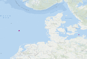
OBS stations of the GEOSTOR project in the German Bight and in the German Baltic Sea

Inhalt
  • Übersicht
  • Be­schrei­bung
    Aktualität des Datensatzes
  • Raumbezug
  • Verweise und Downloads
    Downloads Querverweise Weitere Verweise
  • Nutzung
  • Kontakt
    Point of Contact
  • Fach­informationen
    Informationen zum Datensatz Zusatzinformationen Schlag­worte
  • Metadatensatz

Downloads (1)

https://download.bgr.de/bgr/geostor/obs/shp/geostor-obs.zip Daten im Format Shape

Querverweise (1)

WMS
OBS stations of the GEOSTOR project in the German Bight and in the German Baltic Sea (WMS)
The dataset includes the locations of OBS stations (Ocean Bottom Seismometers) operated in the German Bight during cruise MSM100 with R.V. Maria S. Merian. The time interval from 13.05.2021 to 15.05.2021 has been analysed in a phase without airgun operation for passive recording with 4.5 Hz geophones. Furthermore, the dataset contains locations of 3 broadband OBS systems which were operated during an experiment at the Darss ramp in the German Baltic Sea. The records were analysed in the time interval 23.01.2018 to 01.04.2018.
Kartenansicht öffnen

Nutzungs­bedingun­gen

Datenlizenz Deutschland Namensnennung 2.0Quellenvermerk: GEOSTOR-OBS

Point of Contact

Bundesanstalt für Geowissenschaften und Rohstoffe (BGR)

Marine_Seismik@bgr.de

Vorschau

img

Kartenansicht öffnen

Be­schrei­bung

GEOSTOR-OBS

The dataset includes the locations of OBS stations (Ocean Bottom Seismometers) operated in the German Bight during cruise MSM100 with R.V. Maria S. Merian. The time interval from 13.05.2021 to 15.05.2021 has been analysed in a phase without airgun operation for passive recording with 4.5 Hz geophones. Furthermore, the dataset contains locations of 3 broadband OBS systems which were operated during an experiment at the Darss ramp in the German Baltic Sea. The records were analysed in the time interval 23.01.2018 to 01.04.2018. Der Datensatz beinhaltet die Positionen der Ozeanboden-Seismometer (OBS-Sensoren), die während der Fahrt MSM100 im Projekt GeoBasis3D mit der Maria S. Merian im Jahr 2021 in der Deutschen Bucht ausgebracht wurden. Analysiert wurde der Zeitraum vom 13.05.2021 bis zum 15.05.2021 im Rahmen des Geostor-Projektes, in dem keine Airguns betrieben wurden und rein passive Aufzeichnungen vorliegen. Weiterhin enthält der Datensatz die Positionen von 3 OBS-Geräten aus einem Experiment an der Darsser Schwelle in der Deutschen Ostsee, deren Aufzeichnungen aus dem Zeitraum vom 23.01.2018 bis zum 01.04.2018 analysiert wurden.

Aktualität des Datensatzes

Publication

31.07.2024

Status

completed

Raumbezug

Lage der Geodaten (in WGS84)
SW Länge/Breite NO Länge/Breite
4.657°/54.7° 12.695°/55.259°
Koordinaten­system
EPSG:4326

Verweise und Downloads

Downloads (1)

https://download.bgr.de/bgr/geostor/obs/shp/geostor-obs.zip Daten im Format Shape

Querverweise (1)

WMS
Geodatendienst
OBS stations of the GEOSTOR project in the German Bight and in the German Baltic Sea (WMS)
img
The dataset includes the locations of OBS stations (Ocean Bottom Seismometers) operated in the German Bight during cruise MSM100 with R.V. Maria S. Merian. The time interval from 13.05.2021 to 15.05.2021 has been analysed in a phase without airgun operation for passive recording with 4.5 Hz geophones. Furthermore, the dataset contains locations of 3 broadband OBS systems which were operated during an experiment at the Darss ramp in the German Baltic Sea. The records were analysed in the time interval 23.01.2018 to 01.04.2018.
Kartenansicht öffnen

Weitere Verweise (3)

https://geostor.cdrmare.de/ Information Geostor-Webseite
https://geostor.cdrmare.de/data Information Geostor-Datenkatalog
https://www.bgr.bund.de/DE/Themen/Nutzung_tieferer_Untergrund_CO2Speicherung/Projekte/CO2Speicherung/Laufend/GEOSTOR.html Information BGR-Projektseite

Nutzung

Nutzungs­bedingun­gen

Datenlizenz Deutschland Namensnennung 2.0Quellenvermerk: GEOSTOR-OBS

Dieser Datensatz kann gemäß der Lizenz "Datenlizenz Deutschland Namensnennung 2.0" (https://www.govdata.de/dl-de/by-2-0) genutzt werden.

Zugriffs­beschränkun­gen

no limitations to public access

Kontakt

Point of Contact

Bundesanstalt für Geowissenschaften und Rohstoffe (BGR)

Stilleweg 2
30655 Hannover
Deutschland

Marine_Seismik@bgr.de

Fach­informationen

Informationen zum Datensatz

Identifikator

https://registry.gdi-de.org/id/de.bund.bgr.csw/62d52001-156a-0f9e-5fa4-a2b87a8af2d4

Digitale Repräsentation

Vector

Fachliche Grundlage

During the period from the 13th May to the 15th May 2021, BGR has operated Ocean Bottom Seismometers (OBS stations) in the German Bight during the project GeoBasis3D. In a phase without airgun operation for passive recording with 4.5 Hz geophones, the data were analysed. Furthermore, experiments with 3 broadband OBS systems have been made at the Darss ramp in the German Baltic Sea. The recorded data were analysed in the time interval from 23.01.2018 to 01.04.2018.

Zusatzinformationen

Sprache des Daten­satzes

Englisch

Kon­formi­tät
Spezifi­kation der Kon­formi­tät Spezifi­kations­datum Grad der Kon­formi­tät Geprüft mit
VERORDNUNG (EG) Nr. 1089/2010 DER KOMMISSION vom 23. November 2010 zur Durchführung der Richtlinie 2007/2/EG des Europäischen Parlaments und des Rates hinsichtlich der Interoperabilität von Geodatensätzen und -diensten 08.12.2010 siehe dazu die angegebene Durchführungsbestimmung
Datenformat
Name Version Kompressionstechnik Spezifi­kation
online n/a
ESRI Shape n/a

Schlag­worte

INSPIRE-Themen Geology
ISO-Themen­kategorien Geoscientific Information
Suchbegriffe Baltic Sea CO2 Storage CO2-Speicherung Deutsche Bucht GeolDG geophysics Geophysik German Bight Marine geology Meeresgeologie Ocean Bottom Seismometer Ostsee Ozeanboden-Seismometer Seismics Seismik

Informationen zum Metadatensatz

Objekt-ID

ead57417-73ac-43ae-a501-614913d5b732

Aktualität der Metadaten

07.08.2024

Sprache Metadatensatz

Englisch

Datensatz / Datenserie  

Dataset

XML Dar­stellung
Metadaten als XML herunter­laden
Point of Contact (Metadatum)
geodatenmanagement@bgr.de
Metadatenquelle
GeoDaK (Datenkatalog der Bundesanstalt für Geowissenschaften und Rohstoffe)
ni_bubgr
TEST

NUMIS - Das niedersächsische Umweltportal
Niedersächsisches Ministerium für Umwelt,
Energie und Klimaschutz
Hilfe Kontakt Inhalt Impressum Datenschutz Barrierefreiheit
Nach oben

Hilfe

NUMIS NUMIS
UVP UVP